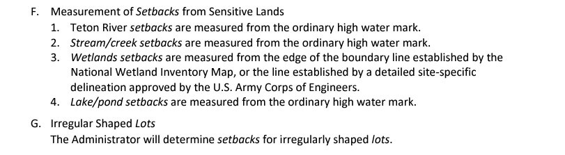
Teton Realty Blog

Teton Region Real Estate Market Stats, Articles & News

  • Home
  • Listings ‘N Stuff
    • Property Search
    • Search Account
  • The Blog
    • Buyers
    • Sellers
    • Local Info
    • Market Reports
    • Know Your Home
    • 2022 Teton County, ID Code
    • Pages & Categories
  • About/Contact Me
    • Contact Me
    • About Me
    • Testimonials
  • Log In/Subscribe
    • Account Set-Up/Log-In
    • Weekly Newsletter
  • Facebook
  • LinkedIn
  • YouTube

Teton County Land Development Code Amendments – Workshop

March 13, 2024 By Tayson Rockefeller Leave a Comment

A workshop has been underway to redline several items in the Teton County Land Development Code (LDC). This review and workshop is ongoing, stay tuned. Please note that much of the information below is an interpretation of the March 12th Planning and Zoning meeting, always verify information with Teton County, Idaho and the most recently published Land Development Code. Just because items below are listed, does not mean that they will be amended. Items that were redlined in the review document (linked here) are in BOLD below.

Teton County has noticed grammatical errors in general errors from public and county staff. Two work sessions were held to review those items with the planning and zoning commission in January 2024 and the county commissioners in March of 2024.

– inaccurate numbers and citations
– table revisions edits in clarifications
– confusion as to when permits are needed
– beekeeping
– ADUs including ADUs in the IR zone (When the new land development code was passed a previous amendment was missed allowing up to two attached ADUs in the IR zone district
– application procedures, land division review and short plat errors
– scenic overlay changes

Notes on the most discussed topics are listed below.

Setbacks
A red line was made with respect to uncovered or unenclosed porches or debts awnings etc that may extend into a required front or side setback up to 2 ft or up to 6 ft into a rear setback. Previously unclosed patios, decks, balconies, porches and so forth were able to encroach into a side or rear setback up to 10 ft. This is likely to avoid issues relative to properties with small setbacks.

Beekeeping
Commercial beekeeping is now defined as 16 hives or larger and discussion about not requiring commercial permits for fewer than 16 hives. Further clarification on what defines a hive (a box, or a stack) was recommended.

Campgrounds
Campgrounds were further defined as campsites with individual water, sure, and or electrical hookups for 2 to 60 tents, recreational vehicles, cabin sites, or travel trailers.

Accessory Dwelling Unit, Attached
Redlines were added in the IR Zone district to accommodate two attached units as an ADU, a code update previously approved prior to the new code, but not included in the final revision to the new code, an inadvertent oversight. The maximum size of the ADU shall not exceed 1500 ft² for either one or two units. The applicant will need to provide verification of wastewater treatment system based on Teton counties septic capacity evaluation form. Applicant is responsible for any fees associated with reviews. ADUs may not be short-term rented in the IR Zone district.

Employee Housing
A controversial element suggested in the code was that the number of employees per unit shall not exceed the number of bedrooms. Planning and zoning commissioners argued that this standard should be limited by fire code requirements or square footage requirements by other entities. *This seemed to be of the greatest concern for the planning and zoning board. Discussion was made to strike this and revert to the septic capacity limits.

Application Subject to Final Decision by the Administrator
As noted below, Scenic Corridor Reviews was added to the list of items that may be at the discretion of the Administrator, more on this is reviewed below.
Temporary Uses
Limited Uses
Agricultural Land Divisions
Sign Permits
Scenic Corridor Reviews
Boundary Line Adjustments, and
Modifications to a Temporary Use

Temporary Uses – Expiration and Revocation
Temporary use permits may not be used in place of a special use permit for an ongoing use – effectively limiting anything more than 180s consecutive days to a special use permit.

Short Plat Land Divisions
The review procedures for the short plat land division process were changed

Preliminary Plat Review
A review criteria was added stating impacts presented from any studies requested related to natural resource overlays, economic impacts, or traffic studies.

Expiration
The application for final plat must be submitted within (previously 36) 24 months of the date of the BOCC’s final decision on the preliminary plat.

Floodplain
Floodplain requirements were amended to be aligned more closely with FEMA requirements.

Grading and Drainage
Amendments were made to the grading and drainage section to add requirements but also intended to reduce the number of permits for special work running through the county. Concern about existing code language including requirements for grading and drainage permits when driveways are elevated more than 6” from existing grade were questioned by the Planning and Zoning Commissioners. Development of an agricultural exempt building, as determined by the building official may now require a grading and drainage permit was also in question.

Riparian Buffers – General Development Standards
Additional language was added to general development standards for any development activity within riparian buffers.

Wildfire Hazard Areas
Small modifications to fuel brakes were discussed and Planning and Zoning Commissioners suggested professional opinions before implementing further changes.

Scenic Resource Protection
*This was an important aspect of my consideration based on special requirements for those close to scenic corridors including State Highways and Ski Hill Road. A general statement was added in applicability that Permits to develop within the scenic corridor may be approved administratively if all development standards are met. At the discretion of the planning administrator, any applications that do not fully meet the standards will require a public meeting to review the application and the planning and zoning commission who will act as the decision-making body.

Submittals
Additional submittals in the section were added for site plans, applications, including the latest recorded deed to a property, affidavits of legal interest if applicable, and landscaping plan including height of landscaping and plant species.

Summary
The Planning and Zoning moved to recommend approval with conditions with a condition to strike the redline limit on employee housing occupancy and continue discussions on defensible space and grading and erosion.

NEW ZONING AND LAND DEVELOPMENT CODE | PART III, WHAT CAN I DO WITH MY PROPERTY? (LAND USE – TETON COUNTY, ID)

November 23, 2022 By Tayson Rockefeller Leave a Comment

As a reminder, this is the third part in a multi-part blog article describing Teton Valley’s new zoning map and land use code. Always refer to the actual and most recent revision of the code, and keep in mind that this is for the unincorporated areas of Teton County and does not include the city limits of Driggs, Victor, or Tetonia. This does not include Alta Wyoming, refer to Teton County, Wyoming for land use regulations there. This article does not account for subdivision covenants, conditions and restrictions, which would be an additional layer above the county regulations. In the event that the county regulations provide for a use, setback or otherwise, you can generally expect that the county restrictions will supersede those outlined in any subdivision documents.

RESIDENTIAL ZONE USES

As described in the first two parts of this article, there are essentially two types of zones with varying density requirements. While it’s a bit more complex, there is essentially an agricultural/residential zone and an industrial zone. You can find an overview of the zone types in Part I, here.

What can I build?
Agriculture or residential zones (which account for almost all zones aside from the industrial zone) allow for a primary dwelling unit or a single-family home. Keeping in mind any subdivision restrictions, they would also allow for an agricultural building or operation, and an attached accessory unit. We will go into that in a little more detail, below.

*Height limitation: 30 ft
*Agricultural Building height limitation: 60 ft
***Maximum Height Limitations vary with development located within 500′ of right-of-ways along Ski Hill Road, State HWY 31, 32 & 33.

*Setbacks: Refer to Part II, here for each zone. In addition, any physical development near the Teton River must be setback 100’ from the ordinary high water mark, and 50’ from any other stream, creek or pond, see below tables:

*Ridgeline Construction: Physical development shall not breach ridgelines as viewed from State highways. If this is unavoidable, a “visual resource analysis” is required.

*** Other factors can impact setbacks (including but not limited to), development and building allowances, including irregular shaped lots, roads, site features, utilities and overlays such as wildlife and fire overlays.

Accessory Buildings (sheds, etc)
Accessory buildings such as a tool shed or storage shed are allowed in all county zones. They must adhere to the dimensional standards required by each zone district, primarily height and setback requirements.

Building Permits
Building permits are required for any structure over 200 SqFt unless it is a dwelling, in which case a permit will be required for any size.

Manufactured & Modular Homes
Manufactured homes, except those built prior to 1976 are allowed as long as they are constructed to satisfy the uniform building code (UBC). Modular homes are also subject to the building codes.

Guest Houses
Also known as accessory dwelling units, these standards vary based on the zoning type. ONE guest house is allowed per parcel where appropriate parking and wastewater treatment provisions are installed, with maximum square footage requirements as follows;
*Attached Guest Houses: must not exceed 1500 SqFt.
*Detached Guest Houses:
Parcel Size | Maximum Sq Ft
7.5 acres+ | 1500 SqFt
2.5 – 7.5 acres | 1200 SqFt
<2.5 acre | 900 SqFt

Short-Term Rentals
Short-term rentals are loosely defined as lodging for terms of 30 consecutive days or less. We’ve talked about Idaho’s legislature in past articles, so it is difficult for any municipality or land use code to restrict short term rentals. However, there are some limitations on use. It’s important to also keep in mind that homeowners associations can restrict short-term rentals, but most do not. Aside from some basic guidelines that would seem obvious, here are some highlights:
1) You must obtain a short-term rental business permit (which does carry a fee), and it must be determined that the wastewater treatment system is sufficient for the size of home.
2) There are county-wide quiet hours from 8:00 p.m. to 8:00 a.m.
3) Special events (weddings are a good example) with guests beyond those allowed on the property must obtain a temporary use permit.
4) Smoke detectors, carbon monoxide detectors and fire extinguishers must be installed.
5) All Property owners within 200 ft of the short-term rental property shall send written notice, including contact information.
6) The address and access directions must be posted on the inside front door.

Bed and Breakfast
A bed and breakfast can be allowed on a limited use basis for up to three units. 4 to 8 units may be allowed with a special use permit approved by the Planning and Zoning Commission and Board of County Commissioners. In addition to the short-term rental regulations, the B&B must maintain the residential character of the neighborhood with no business-related storage warehouses or supplies allowed outside. One sign is allowed that is no larger than 3 SqFt, there must be central dining facilities and any food service must be reviewed and approved by the Teton County Fire Marshall. In addition, a food license or proven exemption must be obtained from East Idaho Public Health.

Campgrounds
Campgrounds are considered with a special use permit in all zones except for the RN-5 Rural Neighborhood zone and the areas of impact. In addition, here are some basic requirements that must be met before a proposal will be considered by the Planning and Zoning Commission and Board of County Commissioners:
Minimum Lot Size | Maximum Camp Sites
40 acres | 20 campsites
60 acres | 30 campsites
80 acres | 40 campsites
100 acres | 20 campsites
40 acres | 50 campsites
120 acres | 60 campsites

Additional guidelines include:
1) 80% of the sites must remain as undeveloped open space Parks or recreational amenities.
2) tent sites must include a level pad at least 150 SqFt and parking at least 200 ft in size. RV sites must be at least 1,350 SqFt to accommodate an RV and parking in addition to hook ups that meet state and local requirements.
3) 200 ft property setbacks.
4) Wastewater systems must be approved by East Idaho public health.
5) All interior roads must meet Teton County fire department requirements.
6) Screening on property sides.
7) Stays shall be limited to 14 consecutive days (or less).

Note that there is also a long-term rental campground with similar restrictions and a minimum stay of 31 consecutive days. It’s important to keep in mind that the same property cannot offer both long-term and short-term camping.

Glamping (Resort Style Campgrounds)
Similar to campgrounds, resort style campgrounds can be allowed with a special use permit in all zones (again, this will require Planning and Zoning and Board of County Commissioners approval) with the exception of the RN-5 Rural Neighborhood zone and the areas of impact.

The regulations for resort campgrounds (aka glamping with tipi’s, yurts, cabins or tiny homes) you have similar restrictions to campgrounds with these highlights:
1) “Units” to be 500 ft or smaller.
2) Minimum lot size to be 40 acres.
3) A maximum of 10 units or less.
4) All facilities, platforms, structures and wastewater treatment shall be provided and comply with state and local building code requirements and East Idaho Public Health requirements.

Daycares
Daycares are allowed in all zones except the industrial zones with a special use permit which again requires Planning & Zoning and Board of County Commissioners approval. They do have obvious regulations for health and safety. Home daycares are allowed on a limited use basis which would not require the aforementioned approvals, but do have some regulation.

INDUSTRIAL/RESEARCH ZONE USES

The industrial zone is suitable for business oriented uses with uses such as outdoor storage, vehicle service and repair, distribution, warehouse and other similar uses permitted, and a variety of other uses (usually not otherwise permitted) allowed on a limited or special use basis.

Dwellings
While standalone dwellings are not permitted in the industrial zones, attached accessory dwelling units are allowed with limitations, and short-term rentals are not allowed.

USE TABLE SUMMARY

Below is a “Use Table” with various categories and specified uses. You can refer to the zoning map overview in Part I, here.
The use table establishes allowed uses by zone district. No building or lot may be used except for
a purpose allowed in the district in which it is located.
3-2-1 Use Table Key
A. Permitted Use (P)
Indicates a use that is allowed or permitted by right in the respective district. The use is also
subject to all other applicable requirements of the LDC.
B. Limited Use (L)
Indicates a use that is allowed in the respective district, by Planning Administrator approval per
Section 4-1-3 herein, subject to specific use and dimensional standards. The locations of the
relevant use standards are found in the definitions in Sections 3-3 to 3-8-10. The use is also
subject to all other applicable requirements of the LDC.
C. Special Use (S)
Indicates a use that may be allowed in the respective district only after recommendation by the
PZC and approval by the BoCC as set forth in Chapter 4. Special uses are subject to all other
applicable requirements of the LDC, including any applicable use standards, except where the
use standards are expressly modified as part of the approval process.
D. Uses Not Permitted (–)
Indicates that a use that is not allowed in the respective district.

NEW ZONING AND LAND DEVELOPMENT CODE | PART II, ZONING DISTRICTS (TETON COUNTY, ID)

September 13, 2022 By Tayson Rockefeller Leave a Comment

Usual Disclaimer; this is MY interpretation of Teton County’s new code. You can find a complete version of the code HERE. Information should always be confirmed with Teton County, Idaho.

As outlined in the first part of my series breaking down the 2022 code, there are 7 zoning types in the unincorporated areas of Teton County, Idaho. Below is a breakdown with differences in each. This does not include the City Limits of Driggs, Victor or Tetonia, or their respective areas of impact.

AREAS OF IMPACT
The Areas of Impact around each city constitute their own zoning districts. However, they are under the jurisdiction of Teton County. Land use and regulations in these areas may be negotiated with each respective city. These are areas of potential annexation into the cities. Although these areas are identified on the new zoning map, we have yet to see details and negotiations between the county and city in these areas. For now, we’ll leave this for another discussion.

AVERAGE DENSITY REFRESHER
As I work through each of the 7 new zones, I’m going to be referring to average density. Remember, this is something (essentially terminology) that the county is pushing as opposed to minimum lot sizes. Essentially, if you had a 40 acre parcel in a 10 acre zone, you could either have four 10 acre parcels, or you could have a cluster of smaller parcels and a larger parcel. In other words, just because you are in a 10 acres zone does not mean that you are required to have 10 acre parcels. In fact, every new zone in the county has a 1 acre minimum lot size. This is all in reference to subdividing land, and we’ll get into that more in another article.

NOTE ABOUT CC&Rs: As I describe the County requirements in each zone, remember that this is a county regulation, not necessarily a subdivision regulation. If you are in a zone with a 30 ft Building height limitation and you are in a subdivision with a 24-foot height limitation, you are still limited to the 24 ft per the subdivision covenants and restrictions.

REFERENCE: The use table for each zone located on page 22 of the Land Development Code.

BREAKING DOWN EACH ZONE

IR, INDUSTRIAL RESEARCH
Minimum lot size:  1 Acre
Minimum lot width: 70′
Minimum front and side setbacks: 10′
Minimum rear setback: 10′
Maximum Building height: 45′ (60′ for agricultural buildings)
Average density requirement: None

Teton County’s description: The Industrial/Research (IR) Zone is intended to accommodate manufacturing, light industrial, office, and research uses with limited accessory residential uses. Most of these areas have low visibility from the highways and tourist centers and are currently undeveloped with some utility services available. Accessory retail and wholesale commercial uses are allowed in the IR Zone, as well as higher impact manufacturing and industrial uses with buffering and other impact mitigating measures as defined in Chapter 3, Use Provisions.

Tayson’s Comments: The industrial research zone is fairly straightforward. Uses like vehicle service and repair and warehouse storage are obviously permitted. Uses that are not permitted include cemeteries, lodges, hospitals, places of worship, a bed and breakfast, daycare, equestrian centers or special event facilities.

An accessory dwelling unit (ADU) that is attached to the main structure is allowed with some limitations, this is an important element to remember when researching something in the industrial zone. Because both main industrial zones are already in subdivisions in Teton County, keep in mind that you would need to review the covenants and restrictions for each development in addition to the standards. Teton county’s definition in section 3-9-2 for an attached accessory dwelling unit states that only one hey do you is allowed per parcel, two parking spaces shall be provided, there’s a maximum size of 1,500 ft and the applicant must provide verification of wastewater treatment.

I’ll get into short-term rentals in another section of the code breakdown, but short-term rentals are not allowed in the industrial zone whereas they are allowed in every other zone in Teton County.

RN-5, RURAL NEIGHBORHOOD
Minimum lot size: 1 Acre
Minimum lot width: 100′
Minimum front and side setbacks: 30′
Minimum rear setback: 40′
Maximum Building height: 30′ (60′ for agricultural buildings)
Average density requirement: 5 Acres (avg density)

Teton County’s description: The Rural Neighborhood (RN-5) Zone is intended to accommodate primarily residential uses at an average density not exceeding one (1) lot per five (5) acres. RN-5 serves as a transitional zone between the Areas of City Impact and rural areas. This zone is intended to serve as a receiving area in a potential Transfer of Development Rights program wherein gross density of one (1) lot per two and a half (2.5) acres would be allowed with the appropriate density credits. Projects in the RN-5 Zone that propose clustered development shall identify areas within the project that are designated as unbuildable open space. The priorities for open space in the RN-5 District include riparian areas, significant areas of native vegetation, important wildlife habitat, and areas for community parks.

Tayson’s Interpretation: The Rural Neighborhood zone offers the highest available density in the unincorporated areas of Teton County with an average maximum density of 5 Acres. Obviously primary dwelling units, outbuildings, attached or detached accessory dwelling units are allowed in this zone as well as home businesses with other conditional uses are also considered.

FH-10, FOOTHILLS
Minimum lot size: 1 Acre
Minimum lot width: 100′
Minimum front and side setbacks: 30′
Minimum rear setback: 40′
Maximum Building height: 30′ (60′ for agricultural buildings)
Average density requirement: 10 Acres (avg density)

Teton County’s description: The Foothills (FH-10) Zone District is intended to ensure development is in harmony with mountainous and hilly settings that are at higher risk to wildfire and notable for wildlife values. FH-10 serves to provide limited residential development with an average density not to exceed one (1) lot per ten (10) acres in the foothills of the Western, Southern, and lower elevation Northeastern portions of the valley. The intent for development in the FH10 is to maintain public access to state and federal lands; discourage scattered hillside development that requires remote roads and infrastructure; follow best practices to help prevent wildfires and minimize threats to life and property when wildfires do occur in the fire prone wildland interface; protect steep slopes; and preserve critical wildlife habitats such as wildlife migration linkage areas at the forest edge, and to protect native vegetation and scenic views of the foothills from the valley floor.

Tayson’s Interpretation: As apparent in the description, the Foothills section was created with wildlife and wildfires in mind to minimize threats in these wooded areas. Here again, obviously, a primary dwelling unit is allowed as well as an attached ADU, with limited use available for a detached ADU. The two Foothills zones are the only zones aside from the industrial zone where detached guest houses are not expressly permitted. The used table does provide for a limited use with respect to detached guest houses which requires planning administrator approval subject to specific use and dimensional standards.

FH-20, FOOTHILLS PRIORITY PROTECTION
Minimum lot size: 1 Acre
Minimum lot width: 100′
Minimum front and side setbacks: 30′
Minimum rear setback: 40′
Maximum Building height: 30′ (60′ for agricultural buildings)
Average density requirement: 20 Acres (avg density)

Teton County’s description: The Foothills Priority Protection (FH-20) Zone District is intended to ensure development is in harmony with mountainous and hilly settings that are at higher risk to wildfire and are of high priority for protection of known wildlife values. FH-20 serves to provide limited residential development with an average density not to exceed one (1) lot per twenty (20) acres in the higher elevation foothills of the Northeastern portion of the valley. The intent for development in the FH-20 is to maintain public access to state and federal lands; discourage scattered hillside development that requires remote roads and infrastructure; follow best practices to help prevent wildfires and minimize threats to life and property when wildfires do occur in the fire prone wildland interface; protect steep slopes; and preserve critical wildlife habitats such as wildlife migration linkage areas at the forest edge, and to protect native vegetation and scenic views of the foothills from the valley floor.

Tayson’s Interpretation: The Foothills priority protection zone is more or less the same as the Foothills zone with a few slight changes. The primary difference is obviously the density with a 20 acre minimum average density as opposed to 10 in the Foothills zone, but there are some considerations for access to public lands, and the use table provides for a few small differences including no limited use for an agricultural auction facility, no limited use for a garden center, more use options for a dude ranch, no special use consideration for vehicle service and repair, and no allowance for any form of wireless communication tower. The same rules apply with respect to detached ADUs and this zone with a limitation on use and a requirement for Planning Administrator approval.

RR-20, RURAL RESIDENTIAL
Minimum lot size: 1 Acre
Minimum lot width: 100′
Minimum front and side setbacks: 30′
Minimum rear setback: 40′
Maximum Building height: 30′ (60′ for agricultural buildings)
Average density requirement: 20 Acres (avg density)

Teton County’s description: The Rural Residential Zone (known as Mixed Agriculture/Rural Neighborhood in the comprehensive plan) is established to allow residential development with an average density not to exceed one (1) lot per twenty (20) acres near the incorporated areas while maintaining the rural atmosphere of Teton County. RR-20 serves to provide a place in the County where residential dwellings may be interspersed with agricultural uses and provide opportunities for residents to have gardens, farm animals, and livestock. The intent of the RR-20 is to keep land in agricultural production, preserve open space, and protect native vegetation, riparian areas, and critical wildlife habitat.

Tayson’s Interpretation: The rural residential zone is essentially an in-between zone from the rural neighborhood to the rural agriculture zones with very similar use requirements. In addition to your primary residence, detached ADUs or guest houses are permitted.

RA-35, RURAL AGRICULTURE
Minimum lot size: 1 Acre
Minimum lot width: 100′
Minimum front and side setbacks: 30′
Minimum rear setback: 40′
Maximum Building height: 30′ (60′ for agricultural buildings)
Average density requirement: 35 Acres (avg density)
Teton County’s description: The Rural Agriculture (RA-35) Zone is established to provide areas primarily used for agricultural purposes and very low density residential with an average density not to exceed one (1) lot per thirty-five (35) acres. The intent of RA-35 zoning is to provide locations for the cultivation of crops, the raising and keeping of livestock, and other related agricultural uses. The RA-35 zone district also serves to nurture wildlife habitats and preserve the beauty of the rural agricultural lands in Teton County by utilizing clustered development designs. It also provides the opportunity to use average residential density to establish smaller residential lots for family use or development while preserving agricultural lands.

Tayson’s Interpretation: The real agricultural zone is somewhat self-explanatory. It has a minimum density requirement of 35 Acres with the intent to leave room for agriculture, raising livestock, etc. The county would like to promote clustered residential areas in this zone to keep these wide open spaces… wide open.

The uses in this zone are fairly broad with limitations on some items that you find available in the rural neighborhood zones such as vehicle and equipment sales with a limited use option, but with more allowable uses that might conform to larger spaces such as consideration for an outdoor University, permitted uses for a riding academy/equestrian center, etc. Both attached and detached ADUs are allowed.

LA-35, LOWLAND AGRICULTURE
Minimum lot size: 1 Acre
Minimum lot width: 100′
Minimum front and side setbacks: 30′
Minimum rear setback: 40′
Maximum Building height: 30′ (60′ for agricultural buildings)
Average density requirement: 35 Acres (avg density)

Teton County’s description: The Lowland Agriculture (LA-35) zone district (known as Mixed Agriculture/Wetland in the comprehensive plan) allows an average density not to exceed one (1) lot per thirty-five (35) acres. It includes areas where development may be limited due to the remoteness of services, topography, jurisdictional wetlands, floodplains, and other sensitive environmental issues. These areas have seasonally important wildlife resources, are predominately rangeland and agriculture land, and have high scenic qualities. The intent of the LA-35 zone is to maintain undeveloped floodplains, protect homes from the risk of flooding, protect water quality from the impacts of development, and protect native vegetation and critical wildlife habitat.

Tayson’s Interpretation: The lowland agricultural zone is more or less similar to the rural agricultural zone with a few limitations that make sense to protect wildlife and other considerations in these areas. An example might include a limitation on employee housing in this zone, that is allowed with a special use approval in the rural agricultural zone. Here again, both attached and detached ADUs are allowed.

NEW ZONING AND LAND DEVELOPMENT CODE | PART I, ZONING OVERVIEW (TETON COUNTY, ID)

August 3, 2022 By Tayson Rockefeller Leave a Comment

For those of you that take the time to read my blog (thank you) you know that I try to make the information relevant to the region. I will begin trickling blog posts in with information on the new zoning and land development code impacting the unincorporated areas passed July 6th, 2022. I will include a “2022 Teton County, ID Code” blog category which you can find in “THE BLOG” section, above. I am going to begin with an overview of the zoning changes which I felt I could better explain in a video, below. Enjoy, and stay tuned for articles to follow breaking down the 2022 Land Development Code for Teton County, Idaho.

The Board of County Commissioners adopted a new Land Development Code on Wednesday, July 6, 2022. It will become effective on August 3, 2022, after it has been noticed in the local newspaper for two weeks. Note: New City Area of Impact (AOI) zoning will soon be renegotiated between city and County governments. Victor and Tetonia AOIs remain as County 2.5-acre minimum lot size in the meantime. The Driggs AOI retains its own unique zoning  scheme until the zoning is renegotiated.

TETON COUNTY, IDAHO ZONING ANNOUNCEMENT

TETON COUNTY, IDAHO LAND DEVELOPMENT CODE ANNOUNCEMENT

New Land Development Code in Effect August 3rd, 2022Land Development Code*All complete applications submitted by August 2nd, 2022 will be reviewed under Title 8 and Title 9 current regulations*
Frequently Asked Questions:  

Can the new county code be adopted by the voters of Teton County, Idaho? 

Zoning ordinances are not able to be adopted by initiative. I.C. §34-1801B(22) states that the broadly constructed individual right to petition via initiative and referendum simply, “does not apply to any local zoning legislation including, but not limited to, ordinances required or authorized pursuant to chapter 65, title 67. This was established in 2018 with the passage of House Bill No. 568 which amended the states initiative and referendum procedures to prohibit voter approval of local zoning legislation or any actions authorized by LLUPA. This includes comprehensive plans, zoning ordinances, subdivision ordinances, variances, and conditional use permits. 

“When will the new Code take effect?” 

The new Teton County Land Development Code will take effect when adopted by the Board of County  Commissioners. This is expected to occur in 2022 after the final public hearing and review. 

“Does this Code change development standards for the entire valley?” 

It does not.  

Teton County contains seven different land planning jurisdictions—the three cities of Victor, Driggs and  Tetonia, the three doughnut-shaped areas of impact (AOI’s) that surround each city, and the  unincorporated county beyond the AOI’s. The new Teton County Land Development Code will only govern  development in the seventh jurisdiction—the unincorporated rural parts of the county outside of the  cities’ areas of impact.  

The cities of Driggs, Tetonia and Victor will remain as high-density areas of development under their  respective individual development ordinances. The three areas of impact surrounding each city will  remain under the control of individual AOI agreements negotiated between each city and the county.  They are intended to contain transitional zoning with densities that are lower than the cities but higher  than the rural county. 

“Will the Code make existing landowners comply with new standards?” Existing buildings and development will not be affected by the new draft Code. They will be allowed to  continue as “nonconforming uses.” Existing lots that don’t comply with new density assignments will be  allowed to be developed per their original entitlements. The new LDC only regulates new land division  proposals and establishes minimal regulation of short-term rentals. 

Nonconforming structures: If structures become non-conforming, it only means they are not up to code.  Most old structures of any age fall into this category each year, as the International Building Code gets  updated every three years or a land development code gets changed over time. 

Teton County Land Development Code Update | Executive Summary of Changes 4 

With any new Land Development Code that gets adopted, it applies only to new construction projects and  new developments. What is already built, subdivided and existing now is not affected by new density  requirements, fencing requirements, height limits or view corridor requirements. No one will ever be  asked to tear down or replace existing structures by a governing body. 

“I heard the Scenic View Corridor set back was 1000 feet!”

Regarding scenic view corridors, the set back is not 1000 feet along the highway. The initial sentence in  the draft pertains to the definition of a view. The draft ordinance originates from state law.  

The LDC draft has two types of scenic corridor protections: type 1 and type 2. Both have design review  provisions for development that occurs within 500 feet. There are options for new applicants within that  500’ distance for graduated increases in height limits as the home location steps back from the right of  way.  

“How will the new Code affect my home business?” 

Small home businesses in residential zones have become less restricted in the draft LDC. What was a four page section of restrictions in the old code, is now just one page. A business sign is now allowed with a  permit for starters.  

The restrictions, for example, on deliveries of ten per day, sets a limit of what neighbors could be impacted  by from small businesses in their residential zone. The use standards for home business are listed in 3-9- 6 of the proposed LDC.  

Any home business with traffic and high levels of activity in one form or another that has outgrown a  home business may be classed as light home industrial. If at any point the home business or home industry  exceeds the standards for a residential zone, it needs to relocate to a commercially zoned parcel. 

“How will the new Code affect my short-term rental?” 

Because of the rapid unregulated spread of short-term rentals throughout the county, and since Idaho  Statute allows for a county or city to implement “reasonable regulations….to safeguard the public health,  safety and general welfare,” the new Teton County code does establish standards for parking, limits the  ensures that the allowed numbers of occupants are appropriate for the septic size, establishes quiet  hours, and sets other basic civil standards. The new draft Code additionally establishes requirements for  trash storage, smoke detectors, etc. 

Short-term rentals will be required to obtain a Short-Term Rental Registration (Permit) with the Planning  Department to verify that use standards have been met prior to the use being approved. A building  inspection may be performed prior to permit issuance. A permit will identify the owner of the property  and their contact information. Property management contact information, if applicable, will also be listed.  

The permit requires notification of the neighbors in each direction that may be impacted by the new rental  activity. Having proof of emails or letters that notify neighbors 30 days prior to the start of rental activity  is the new requirement in the LDC. 

Property owners and managers that follow these guidelines will reduce the number of problems for  neighborhoods throughout the valley.

Teton County Land Development Code Update | Executive Summary of Changes 5 

“Why change the zoning districts?” 

Teton County’s existing Zoning Map identifies basically two zone densities in the unincorporated parts of  the valley—A-20 and A/R-2.5. These zones were established in the early 1990’s, were largely self-assigned  by property owners, were not based on a comprehensive plan, and only vaguely reflect the valley’s actual  land use patterns and landforms. In contrast, the Comprehensive Plan’s Framework Map identifies six  zones which have been delineated according to actual topography and existing settlement patterns. These  include Rural Agriculture, Rural Neighborhood, Foothills, Mixed Ag/Rural Neighborhood, Mixed  Ag/Wetland, and Industrial/Research. 

“Why change density assignments?” 

The Comprehensive Plan calls for changes in how lands may be divided in each zone, including revised  densities. In response, the Steering Committee, the Planning and Zoning Commissioners, and the Board  of County Commissioners have worked out a new set of densities to better reflect the needs of the Coutny  and the Comprehensive Plan: Rural Agriculture- 35-acre, Mixed Ag/Wetland-35-acre, Mixed Ag/Rural  Neighborhood-20 acre, Foothills-10-acre, Foothills- 20-acre, Rural Neighborhood-7.5 acre, and  Industrial/Research.  

Update: In subsequent editing by the P&Z Commission, Rural Agriculture zoning was revised to 35-acre zoning and Mixed Ag/Rural Neighborhood was revised to 7.5-acre zoning. 

The current valley-wide basic densities of 2.5 acres and 20 acres offer little choice and are relatively small  in size for a rural community. 20-acre zoning is simply too small for most agricultural purposes and does  little to protect meaningful open space. Other comparable mountain communities around the Rockies  offer both a wider range of assigned densities, and far lower density limits (with corresponding higher  acreage numbers). 

“Why switch to average density zoning?” 

For the most part, the LDC Steering Committee proposed to get rid of minimum lot size requirements in  favor of using average density as the guiding principle in how many lots can be created in a subdivision (a  1-acre minimum lot size is planned to remain in all zones to accommodate fundamental well-septic  separation requirements). By definition, this would allow clustering by right. This change represents a  major shift in land development policy for the county. It is absolutely intended to help families get the  additional lots they desire and keep quality farmland and families together. It is a win for everyone. 

Average density zoning provides greater flexibility for property owners and developers, while allowing the  community to reach many of its most important goals from the Comp Plan. An enormous advantage of  average density zoning is that rather than having all the land in the parcel incorporated into lots, any land  leftover could either be put into a conservation easement, deeded to a homeowners’ association, left as  a working farm or otherwise utilized in a similar manner. 

“Can I split off a small piece of land to give/sell to one of my family members? How?” Two methods are available to larger landowners to achieve this goal. The first is to simply utilize the  average density zoning method just described in the previous answer. The second is to utilize a short plat land division to divide acreage into up to four parcels.

Teton County Land Development Code Update | Executive Summary of Changes 6 

“How does the new Code help protect wildlife and natural resources as highlighted in the  Comp Plan?” 

All development proposed within wildlife habitat as identified on the Teton County Natural Resource  Overlay Map will be subject to Site Plan review to ensure that the location of proposed development or  use avoids or mitigates impacts to indicator species and indicator habitats to the extent practical. The  location of proposed development will reduce fragmentation of habitat, avoid locations that affect  landscape elements such as unique rock formations, sheltered draws, drainage ways, or other features,  maintain connectivity among habitats, and protect sensitive fish and wildlife breeding areas and winter  ranges. 

If impacts cannot be avoided, the lost habitat will be required to be mitigated by replacing it with similar  vegetation communities at a one to one (1:1) ratio. The replacement ratio must be higher within a half  mile of riparian areas and equal a two-to-one (2:1) ratio. Perimeter fencing will need to be wildlife  friendly—this requirement does not apply to privacy fencing used to enclose the living space immediately  adjacent to a Dwelling Unit. 

If a subdivision proposal falls within the natural resource overlays, the Administrator, Planning  Commissioners or BoCC may ask for a more detailed Natural Resource Analysis.  

“How is the Code different from the Comprehensive Plan?” 

Both a Comprehensive Plan and a Land Development Code are required by state statutes contained in  Idaho’s Local Land Use Planning Act. The Comprehensive Plan is a conceptual document outlining the  community’s vision and goals. In Teton County’s case, our Comprehensive Plan was adopted by a BoCC  resolution in 2012. The Code is then supposed to be built from the Comprehensive Plan’s outline into a  working set of ordinances.

  • « Previous Page
  • 1
  • 2

Recent Testimonials

  • Douglas V.
  • Chuck M.
  • Terry & Joy K.
Teton Valley Realty
Copyright Teton Realty Blog© 2025 - Tayson Rockefeller - [email protected] - 208-709-1333 - sitemap | Privacy Policy, Copyright & Terms of Use