Teton Realty Blog

Teton Region Real Estate Market Stats, Articles & News

  • Home
  • Listings ‘N Stuff
    • Property Search
    • Search Account
  • The Blog
    • Buyers
    • Sellers
    • Local Info
    • Market Reports
    • Know Your Home
    • 2022 Teton County, ID Code
    • Pages & Categories
  • About/Contact Me
    • Contact Me
    • About Me
    • Testimonials
  • Log In/Subscribe
    • Account Set-Up/Log-In
    • Weekly Newsletter
  • Facebook
  • LinkedIn
  • YouTube

Floodplain, who’s in charge, and what does it mean?

May 2, 2025 By Tayson Rockefeller Leave a Comment

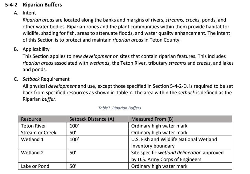
For some reason, of all the “layers” encompassing lands throughout Teton Valley (or anywhere else), floodplain has always been the most difficult for me to understand. Merriam-Webster defines floodplain as “level land that may be submerged by floodwaters, or a plain built up by stream deposition.” To me, floodplain isn’t necessarily always flat, but it isn’t the definition that I struggle with. It more has to do with what it means for those that have floodplains indicated on their property.

Before I go any further here, and with my preface out of the way, I STILL struggle with floodplain. With that—and all articles I have written over the years—take this with a grain of salt. These are my interpretations about complex issues, and I have no authority on these matters. Always do your own research through proper authoritative agencies.

Tayson’s definition of floodplain, and the purpose of having this information:

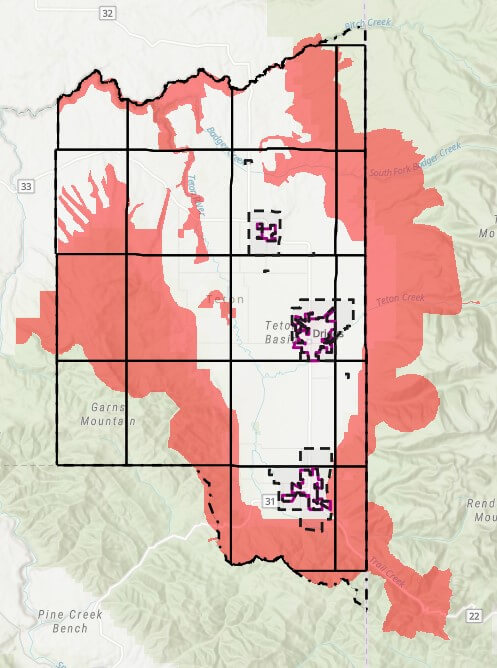
I don’t think anybody’s really struggling with the definition here, but to expand: Floodplain, as I understand it, is determined through elevation (obviously the low-lying areas are going to accumulate water), hydrology (how water moves), and soil types. For example, in a past article I talked about attending a FEMA open house at the Teton County Courthouse, which detailed how this data is collected and how the County is working with FEMA to update its flood maps. As of this writing, the appeal period for those wishing to contest the proposed maps is closing, paving the way for final approval of the new, more accurate flood zones and associated maps.

The purpose of having this data:

To me, the greatest benefit of having this information is to mitigate risk. In a real-life scenario, I don’t think that Merriam-Webster’s definition works to describe potential areas of risk. Since water moves in precarious ways, we can hope to rely on science and data to give us that clearer picture of areas of risk. This can then be used for landowners to plan new projects or mitigate risk with existing structures. It’s also used by insurance companies—particularly those participating in the National Flood Insurance Program—to assess flood risk and determine insurance requirements. As I understand it, the NFIP is a federal program managed by FEMA that provides flood insurance to property owners, renters, and businesses, and it relies heavily on FEMA’s floodplain maps to assess risk and set insurance rates.

How the data is obtained and displayed:

Again, no expert here, but I do know that the latest information available was provided through LiDAR flyovers to gather contours and terrain, as well as hydrologic and soil studies to model how water moves and flows. Because of the level of technology, these maps can display not only areas of concern but also different levels of risk in certain areas. Historically, my understanding was that the primary defined areas of risk included 100-year and 500-year flood risk areas. I also understand that new efforts are being made to display this risk through percentages as opposed to yearly events, so as not to confuse the intended definition of that risk.

As an example, a property in a 500-year flood risk area does not necessarily mean it will only flood once every 500 years. Describing that same risk as a 0.2% annual chance of flooding conveys the same statistical probability, but in a way that more clearly communicates the level of risk. Similarly, a 100-year flood event area might also be described as having a 1% annual chance of flooding. Because of the advanced technology used to gather this new data, additional flood risk areas can also be defined—but it’s important to remember that these are estimates based on modeling. Obviously, anything can happen.

Who creates the maps?

The maps themselves are generally created through FEMA (Federal Emergency Management Agency) in cooperation with the National Flood Insurance Program (NFIP) and local jurisdictions. FEMA contracts with engineering firms and works with local governments to ensure maps reflect both scientific modeling and local conditions. These are the same maps used for regulating development in flood-prone areas and determining flood insurance requirements.

Can the information be challenged?

As advanced as this data might be, it is broadly used across great areas of landscape. As a result, property owners or developers may have the opportunity to challenge this data through site-specific engineering to determine the exact elevation of a structure relative to the projected floodwaters. This is typically done through an elevation study, which can then be used to produce an Elevation Certificate. While this certificate is often required for determining compliance with building standards or securing flood insurance, it can also be submitted to FEMA to support a request to remove a structure from a mapped high-risk zone.

In some cases, more formal map changes are needed. A Letter of Map Amendment (LOMA) can be requested when a property owner believes their structure or lot was incorrectly included in a flood zone. These are often supported by Elevation Certificates and typically apply to individual lots or structures. For larger-scale changes—such as those affecting an entire development or subdivision—a Letter of Map Revision (LOMR) may be appropriate. These tools can be essential for developers and landowners when building or remodeling near designated floodplains.

What is the County’s role?

In the event that there is development in a floodplain, the County’s policy (as I interpreted during a meeting with the County on the subject) was for structures to be a minimum of one foot above freeboard.

In that meeting, they referred to something called “freeboard,” which, as it turns out, is a nautical term. In boating, freeboard is the distance between the waterline and the edge of the boat—basically the buffer that keeps water from spilling in. In the floodplain world, it’s a similar idea. Freeboard refers to the extra height that structures need to be built above the projected flood level. It gives a bit of wiggle room for things like model inaccuracies or bigger-than-expected storms. In Teton County, that buffer is currently set at one foot above the base flood elevation for any development in a flood zone, though which zone this applies to should be clarified prior to any construction.

Additionally, the representative in the meeting stated that the County does maintain some generic latitude, which might include looking at developable areas on a building site that may not be in the floodplain. There are also considerations when it comes to vegetation removal in instances of development in or around a floodplain, understanding that removing vegetation can also impact these waterways. Because I have not been able to point to any specific area of the code to identify the County’s requirements in addition to those set forth or recommended by FEMA, it is important to remember to consult with industry professionals and engineers, and to work directly with the planning and zoning and/or building departments to understand what’s allowed, and what’s required.

Teton County Idaho’s FEMA Flood Map Updates

September 22, 2024 By Tayson Rockefeller Leave a Comment

On September 18th, 2024, I attended an open house for a special board with Teton County in conjunction with a FEMA representative for the updated project timeline for new (long-awaited) floodplain maps. Obviously, the information below is my interpretation of that presentation, so always verify information with State, Local and Federal officials.

The purpose of the open house was to review the preliminary floodplain map data released on August 15th. This data was last updated in 1988 with the limited technology at the time. An attempt was made in 2011 to update the mapping with a LIDAR flyover of the county in 2011. However, Teton County GIS coordinator Rob Marin (thanks, Rob) pointed out some deficiencies based on the year and time of year that may have inadvertently resulted in inaccurate and exaggerated flood data. This led to another recent flyover with a greater level of accuracy based on the timing, and newer technology. This new data will lead the way for a 90-day appeal process for those that can provide strong evidence that the new map data is inaccurate. For any objections, it should be noted that a letter of final determination is expected in the Fall of 2025, with final maps taking effect early 2026. The 90 day appeal process is expected to begin in February of 2025 and end in May of 2025. Comments can be provided, and forms are available on site at the Teton County courthouse and online for these appeal processes. This could be something as simple as an incorrect street name, or a more significant appeal such as a formal objection with evidence of inaccuracies. An appeal requires quite a bit of work, and as such, will require some form of significant evidence as to the inaccuracy, usually involving engineering (data based) reports. However, these scenarios will be investigated. These should be provided to Teton County who will pass the comments along to FEMA.

With that out of the way, the meeting was informative as to the new data, how it is mapped, and how it can be beneficial to Teton County. In attendance at the meeting was a representative for FEMA’s Region 10, Marshall Rivers. FEMA’s primary concern is safety, predicting flood risk and preparing for flood events. The last time the flood maps were updated was 1988, and with vast, new technology, FEMA was able to map not only flood information, but ranges of flood risk (as well as a side benefit of 2 foot contour elevations now available from the county). This program for updating the data was in collaboration with local government and the National Flood Insurance Programs (NFIP) in conjunction with FEMA. The federal government is responsible for mapping communities on a continuing basis. The state governments prioritize areas for future mapping studies, and local governments provide local insight and support. They also integrate the data into planning mechanisms and processes.

How are the maps made?

The maps are made using ground survey and LIDAR technology to identify areas of floodplain. The floodplain is generally an area that can be affected by flood or high water. LIDAR is a laser-based aerial tool with extraordinary accuracy that can sense surprisingly small objects. As mentioned above, a byproduct includes two foot contour elevations across almost the entire county. This data can be used by surveyors or land owners for planning and building purposes. There are limitations to these maps which include some uncertainties or uncontrollable circumstances such as log jambs, changing rivers or even land impacted by wildfires. In addition to LIDAR, hydrology and measuring the flow of water is a big consideration in establishing these maps. FEMA worked with Teton County to add study zones with some tasks led by FEMA, and others led by Teton County and other agencies.

Updated Zones and Associated Risks

This new data offers a more granular prediction as to certain areas and their risk levels. Two types of flood hazards were mapped. The moderate flood risk (Yellow, when viewing the map) is intended to show a 0.2% annual chance of flooding (or less impactful areas), and high flood risk which is estimated to be a 1% annual chance of flooding (or more impactful areas). In addition, Floodway (as indicated in these maps in red), indicate areas that could be most impactful, and should be avoided. I was unable to determine the county’s future role in special requirements or restrictions in these areas.

Insurance 

Just because a home is not in one of these identified rest areas, does not mean that there is no risk of flood. Conversely, if your home is removed from these flood areas with the new mapping, it doesn’t necessarily mean that you should cancel your existing flood insurance. According to FEMA, one out of four people who have a claim are not in an area mapped and identified as a high-risk flood area. If your property is added into flood zones in these amended maps, you may be contacted by your lender (and should consider risk insurance, regardless). My understanding is that your flood risk is evaluated by your lender and insurance provider. If homes are built above the base flood elevation of the risk area, this can minimize the added cost, or potentially even the requirement for insurance. You can learn more (and confirm my beliefs) at floodsmart.gov. 

Base Flood Elevation & Development This new data will provide some instant data for what used to require elevation certificates to prove the base flood elevations. Information that may have once required an engineer to evaluate may now be immediately available with the new data. You do need a floodplain development permit whether you are handling infrastructure or building a home, but FEMA does not restrict development in floodplain areas.

OLD DATA (circa 1988)

NEW DATA (as of August 15th, 2024)

Teton County Land Development Code – Wildfire Hazard Areas

September 11, 2024 By Tayson Rockefeller Leave a Comment

As a continuation of the review of the Teton County Land Development Code, a short, but potentially impactful section of the code may affect a property of potential interest, or perhaps your own. This section is 5-4-3, Wildfire Hazard Overlays. Like many sections of the 2022 Land Development Code (LDC), the code does cross reference a “layer” or map overlay. Below is a high level overview of the areas affected by the Wildfire Hazard Areas. The areas affected by the Wildlife Hazard Areas are mostly limited to the perimeter foothills of the Teton Valley, but do include some areas of the valley floor.

As stated in the LDC, the intent of this area is “to protect the health and safety of structures in high-risk wildfire areas”. The greatest impacts of development is the requirement that principal structures shall be located within 200 feet of the primary public roadway to provide safe and efficient access for wildfire protection. In addition, a plan for management of vegetation and defensible space is required to be submitted with site plans, and fuel breaks are to be implemented along access roads, driveways and subdivision boundaries, as well as defensible space provided around principal structures for the International Wildlife-Urban Interface Code (WUI Code). The website for the WUI code can be found here. As a side note, it is expected that ALL of Teton County may be required to conform to the WUI Code.

As with many aspects of our relatively “young” LDC (first established August 2022) these limitations can create challenges for certain properties. At the time of this writing, a few concerns might include (but may not be limited to);

  • Properties where the designated building envelope is further than 200 feet from the public roadway
  • Properties where the most suitable building site (for reasons other than fire hazard) is further than the public roadway
  • Large acreages within 200 feet of a public roadway
  • New subdivision along public roadways

As a final note, the LDC does specifically state “public roadway” when referencing the 200′ distance requirement. As a result, I do expect further discussion at the county level to better define roadways and mitigation requirements for properties that are further than 200′ from public roadways in and of themselves.

Similar to other overlays and code requirements, it is recommended that potential Buyers and Land Owners review ALL aspects of the local codes and ordinances. In the instance of the Wildfire Hazard Overlays, it is recommended that contact is made to a Teton County, Idaho Planning or Building representative to understand current requirements, interpretations and future amendments.

*Wildfire Hazard Overlays as of September 11th, 2024.

NEW ZONING AND LAND DEVELOPMENT CODE | PART III, WHAT CAN I DO WITH MY PROPERTY? (LAND USE – TETON COUNTY, ID)

November 23, 2022 By Tayson Rockefeller Leave a Comment

As a reminder, this is the third part in a multi-part blog article describing Teton Valley’s new zoning map and land use code. Always refer to the actual and most recent revision of the code, and keep in mind that this is for the unincorporated areas of Teton County and does not include the city limits of Driggs, Victor, or Tetonia. This does not include Alta Wyoming, refer to Teton County, Wyoming for land use regulations there. This article does not account for subdivision covenants, conditions and restrictions, which would be an additional layer above the county regulations. In the event that the county regulations provide for a use, setback or otherwise, you can generally expect that the county restrictions will supersede those outlined in any subdivision documents.

RESIDENTIAL ZONE USES

As described in the first two parts of this article, there are essentially two types of zones with varying density requirements. While it’s a bit more complex, there is essentially an agricultural/residential zone and an industrial zone. You can find an overview of the zone types in Part I, here.

What can I build?
Agriculture or residential zones (which account for almost all zones aside from the industrial zone) allow for a primary dwelling unit or a single-family home. Keeping in mind any subdivision restrictions, they would also allow for an agricultural building or operation, and an attached accessory unit. We will go into that in a little more detail, below.

*Height limitation: 30 ft
*Agricultural Building height limitation: 60 ft
***Maximum Height Limitations vary with development located within 500′ of right-of-ways along Ski Hill Road, State HWY 31, 32 & 33.

*Setbacks: Refer to Part II, here for each zone. In addition, any physical development near the Teton River must be setback 100’ from the ordinary high water mark, and 50’ from any other stream, creek or pond, see below tables:

*Ridgeline Construction: Physical development shall not breach ridgelines as viewed from State highways. If this is unavoidable, a “visual resource analysis” is required.

*** Other factors can impact setbacks (including but not limited to), development and building allowances, including irregular shaped lots, roads, site features, utilities and overlays such as wildlife and fire overlays.

Accessory Buildings (sheds, etc)
Accessory buildings such as a tool shed or storage shed are allowed in all county zones. They must adhere to the dimensional standards required by each zone district, primarily height and setback requirements.

Building Permits
Building permits are required for any structure over 200 SqFt unless it is a dwelling, in which case a permit will be required for any size.

Manufactured & Modular Homes
Manufactured homes, except those built prior to 1976 are allowed as long as they are constructed to satisfy the uniform building code (UBC). Modular homes are also subject to the building codes.

Guest Houses
Also known as accessory dwelling units, these standards vary based on the zoning type. ONE guest house is allowed per parcel where appropriate parking and wastewater treatment provisions are installed, with maximum square footage requirements as follows;
*Attached Guest Houses: must not exceed 1500 SqFt.
*Detached Guest Houses:
Parcel Size | Maximum Sq Ft
7.5 acres+ | 1500 SqFt
2.5 – 7.5 acres | 1200 SqFt
<2.5 acre | 900 SqFt

Short-Term Rentals
Short-term rentals are loosely defined as lodging for terms of 30 consecutive days or less. We’ve talked about Idaho’s legislature in past articles, so it is difficult for any municipality or land use code to restrict short term rentals. However, there are some limitations on use. It’s important to also keep in mind that homeowners associations can restrict short-term rentals, but most do not. Aside from some basic guidelines that would seem obvious, here are some highlights:
1) You must obtain a short-term rental business permit (which does carry a fee), and it must be determined that the wastewater treatment system is sufficient for the size of home.
2) There are county-wide quiet hours from 8:00 p.m. to 8:00 a.m.
3) Special events (weddings are a good example) with guests beyond those allowed on the property must obtain a temporary use permit.
4) Smoke detectors, carbon monoxide detectors and fire extinguishers must be installed.
5) All Property owners within 200 ft of the short-term rental property shall send written notice, including contact information.
6) The address and access directions must be posted on the inside front door.

Bed and Breakfast
A bed and breakfast can be allowed on a limited use basis for up to three units. 4 to 8 units may be allowed with a special use permit approved by the Planning and Zoning Commission and Board of County Commissioners. In addition to the short-term rental regulations, the B&B must maintain the residential character of the neighborhood with no business-related storage warehouses or supplies allowed outside. One sign is allowed that is no larger than 3 SqFt, there must be central dining facilities and any food service must be reviewed and approved by the Teton County Fire Marshall. In addition, a food license or proven exemption must be obtained from East Idaho Public Health.

Campgrounds
Campgrounds are considered with a special use permit in all zones except for the RN-5 Rural Neighborhood zone and the areas of impact. In addition, here are some basic requirements that must be met before a proposal will be considered by the Planning and Zoning Commission and Board of County Commissioners:
Minimum Lot Size | Maximum Camp Sites
40 acres | 20 campsites
60 acres | 30 campsites
80 acres | 40 campsites
100 acres | 20 campsites
40 acres | 50 campsites
120 acres | 60 campsites

Additional guidelines include:
1) 80% of the sites must remain as undeveloped open space Parks or recreational amenities.
2) tent sites must include a level pad at least 150 SqFt and parking at least 200 ft in size. RV sites must be at least 1,350 SqFt to accommodate an RV and parking in addition to hook ups that meet state and local requirements.
3) 200 ft property setbacks.
4) Wastewater systems must be approved by East Idaho public health.
5) All interior roads must meet Teton County fire department requirements.
6) Screening on property sides.
7) Stays shall be limited to 14 consecutive days (or less).

Note that there is also a long-term rental campground with similar restrictions and a minimum stay of 31 consecutive days. It’s important to keep in mind that the same property cannot offer both long-term and short-term camping.

Glamping (Resort Style Campgrounds)
Similar to campgrounds, resort style campgrounds can be allowed with a special use permit in all zones (again, this will require Planning and Zoning and Board of County Commissioners approval) with the exception of the RN-5 Rural Neighborhood zone and the areas of impact.

The regulations for resort campgrounds (aka glamping with tipi’s, yurts, cabins or tiny homes) you have similar restrictions to campgrounds with these highlights:
1) “Units” to be 500 ft or smaller.
2) Minimum lot size to be 40 acres.
3) A maximum of 10 units or less.
4) All facilities, platforms, structures and wastewater treatment shall be provided and comply with state and local building code requirements and East Idaho Public Health requirements.

Daycares
Daycares are allowed in all zones except the industrial zones with a special use permit which again requires Planning & Zoning and Board of County Commissioners approval. They do have obvious regulations for health and safety. Home daycares are allowed on a limited use basis which would not require the aforementioned approvals, but do have some regulation.

INDUSTRIAL/RESEARCH ZONE USES

The industrial zone is suitable for business oriented uses with uses such as outdoor storage, vehicle service and repair, distribution, warehouse and other similar uses permitted, and a variety of other uses (usually not otherwise permitted) allowed on a limited or special use basis.

Dwellings
While standalone dwellings are not permitted in the industrial zones, attached accessory dwelling units are allowed with limitations, and short-term rentals are not allowed.

USE TABLE SUMMARY

Below is a “Use Table” with various categories and specified uses. You can refer to the zoning map overview in Part I, here.
The use table establishes allowed uses by zone district. No building or lot may be used except for
a purpose allowed in the district in which it is located.
3-2-1 Use Table Key
A. Permitted Use (P)
Indicates a use that is allowed or permitted by right in the respective district. The use is also
subject to all other applicable requirements of the LDC.
B. Limited Use (L)
Indicates a use that is allowed in the respective district, by Planning Administrator approval per
Section 4-1-3 herein, subject to specific use and dimensional standards. The locations of the
relevant use standards are found in the definitions in Sections 3-3 to 3-8-10. The use is also
subject to all other applicable requirements of the LDC.
C. Special Use (S)
Indicates a use that may be allowed in the respective district only after recommendation by the
PZC and approval by the BoCC as set forth in Chapter 4. Special uses are subject to all other
applicable requirements of the LDC, including any applicable use standards, except where the
use standards are expressly modified as part of the approval process.
D. Uses Not Permitted (–)
Indicates that a use that is not allowed in the respective district.

  • 1
  • 2
  • Next Page »

Recent Testimonials

  • Douglas V.
  • Chuck M.
  • Terry & Joy K.
Teton Valley Realty
Copyright Teton Realty Blog© 2025 - Tayson Rockefeller - [email protected] - 208-709-1333 - sitemap | Privacy Policy, Copyright & Terms of Use