Teton Realty Blog

Teton Region Real Estate Market Stats, Articles & News

  • Home
  • Listings ‘N Stuff
    • Property Search
    • Search Account
  • The Blog
    • Buyers
    • Sellers
    • Local Info
    • Market Reports
    • Know Your Home
    • 2022 Teton County, ID Code
    • Pages & Categories
  • About/Contact Me
    • Contact Me
    • About Me
    • Testimonials
  • Log In/Subscribe
    • Account Set-Up/Log-In
    • Weekly Newsletter
  • Facebook
  • LinkedIn
  • YouTube

HOAs vs Pragmatism

April 3, 2025 By Tayson Rockefeller Leave a Comment

An interesting dynamic that has emerged over the years is the unanticipated change in lifestyle, business practices, zoning updates, county regulations, and state regulations affecting simple, common-sense aspects of everyday living.

One of the most common examples I have referenced over the years is short-term rental regulations. Idaho legislation is widely known for protecting property rights, including the right to rent a home—more specifically, for short-term or vacation rentals. There is, however, a provision allowing homeowners associations (HOAs) to prohibit short-term rentals (typically defined as stays of 30 nights or fewer). The issue is that most of Teton Valley’s new subdivisions were established around 2007, during the last real estate boom. While there was a vacation rental industry at that time, it was still in its early stages. I recall that our in-house property management firm, Teton Valley Property Management, initially used reservation software similar to what a hotel might use. The industry didn’t truly take off until the last real estate boom, coinciding with Airbnb’s launch in 2008.

Many new subdivisions during that period copied previous development covenants and restrictions, making only slight modifications to fit the new developments. As a result, they often failed to account for the potential rise of short-term rentals, even if the original intent was to prevent them. Consequently, nearly every subdivision in Teton Valley allows short-term rentals. Since the last real estate boom, new communities have been established, though they have become less frequent due to zoning density changes and new subdivision requirements. Even so, new developers typically avoid prohibiting rentals out of fear of alienating potential buyers who may see rental income as an advantage.

While the longstanding controversy over short-term rentals is an easy topic to discuss, there are other noteworthy examples of the tension between HOA restrictions and evolving realities.

Environmental Changes

I think we can all generally agree that climate change is real at this point. While this isn’t a topic I typically cover in my neutral real estate blog, it does relate to issues like wildfire resistance. Some communities still require natural wood siding and even shake shingle roofs. As of this writing, Teton Valley has been fortunate to avoid dramatic increases in insurance rates and has experienced very few natural disasters. However, a brush fire in 2024 was one of the first significant fires within the valley in my memory. Despite this, some subdivisions continue to resist changes that would allow for more fire-resistant building materials.

Build-Out and Subdivision Maturity

Issues tend to arise as subdivisions develop. It’s surprising how many communities in Teton Valley remain mostly or partially undeveloped, often due to land investors holding onto property, even if it is just to own a “piece” of Teton Valley. However, some communities are beginning to build out rapidly. While 2007 was a land development boom, the recent uptick in Teton Valley has primarily been in residential development.

Fortunately, most property owners have been considerate of their neighbors when developing. For example, in Teton View corridor neighborhoods without designated building envelopes, many owners stagger their homes to preserve both their own views of the Tetons and those of their neighbors. Even when unintentional, local knowledge of the landscape and architectural intuition tend to guide development in a way that takes advantage of the surrounding beauty. However, this isn’t always the case. Not all property owners are neighborly, and some development factors were not thoroughly vetted during the planning process. I’ve seen multiple subdivisions require amendments to plat maps or building envelopes to accommodate practical adjustments. While HOAs are often cooperative in such cases—particularly when county variances require it—the process of amending subdivision documents can be cumbersome, especially when no formal association has been established.

Zoning Changes

This is the big one. In August 2022, the county introduced an entirely new land development code and zoning map. This update cut densities nearly in half, revised overlays, and altered development processes. While existing parcels were grandfathered in terms of density (for example, a properly subdivided 2.5-acre parcel now within a 5-acre density zone remains buildable), other changes present challenges. Here are a few key examples:

Scenic Corridor Overlay

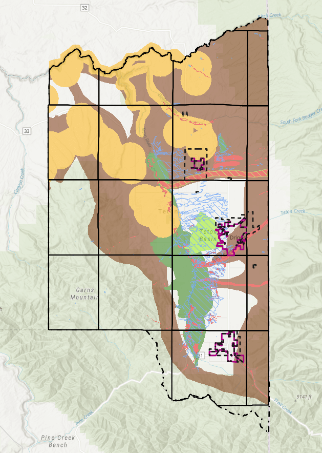
The new scenic corridor overlay affects properties within 500 feet of Ski Hill Road. Under the new regulations, landowners may need to modify development plans to comply with overlay requirements. The county does not enforce subdivision covenants, conditions & restrictions, but its development guidelines supersede those of subdivisions. This can create conflicts when subdivision guidelines contradict county zoning restrictions. Fortunately, the county often grants variances to accommodate developers and subdivisions, though it adds an extra layer of complexity.

Wildlife Overlay

Zoning changes have also impacted properties within designated wildlife and natural resource overlays. While most subdivision parcels under five acres are now exempt from additional requirements, some still face complications. For example, an overlay may sit directly on a planned building site, requiring a variance or adjustment that could conflict with existing subdivision plats.

Wetland and Floodplain Overlays

These overlays have been revised, and riparian buffer setbacks have increased. Even if a wetland delineation was approved years ago, the Army Corps of Engineers has expiration timelines for delineation approvals. As a result, landowners may find that new setbacks prohibit development in previously intended areas. Again, variances are possible, but they add another hurdle for landowners and developers.

Setback Requirements

Simple setback changes can also cause issues. Some subdivisions were designed with minimal setbacks based on previous zoning regulations. If the required setbacks have increased, buildable areas may be reduced, making development more difficult.

Why Not Simply Modify HOA Covenants?

Given these challenges, one might ask: why not update subdivision covenants and HOA policies? While this seems like a logical solution, it is often easier said than done. Many subdivision bylaws require a majority—or even a supermajority—of homeowners to approve amendments. This typically necessitates board meetings, formal votes, and recorded signatures. In my experience, this is a difficult process. Many investors and homeowners are resistant to change, especially if it could affect property values, rental income, or architectural consistency within a community.

Final Thoughts

Despite these challenges, it’s important to note that very few lots are significantly impacted by zoning or covenant conflicts. Still, prospective buyers and developers should carefully review subdivision documents and reach out to HOA representatives when possible. While these changes introduce new complexities, I believe that practical solutions will emerge over time. County officials have reassured me that properly subdivided parcels remain buildable, even if new regulations introduce obstacles. Additional challenges—such as septic system requirements in wet areas and rising construction costs—may also arise.

Teton Valley is still in the early stages of its growth, despite the substantial expansion we’ve seen. I anticipate further zoning updates, new comprehensive plans, and evolving industry standards will continue to shape the landscape (no pun intended). But if history is any indication, just like past controversial real estate issues in Teton Valley, my prediction remains simple: things will work themselves out.

Teton County Land Development Code – Wildfire Hazard Areas

September 11, 2024 By Tayson Rockefeller Leave a Comment

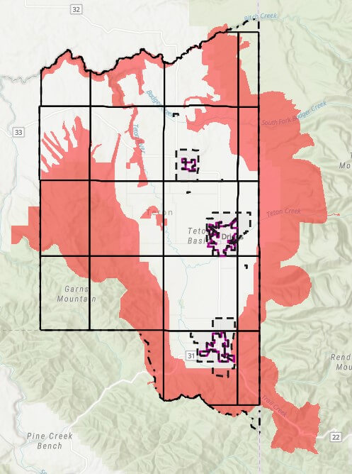
As a continuation of the review of the Teton County Land Development Code, a short, but potentially impactful section of the code may affect a property of potential interest, or perhaps your own. This section is 5-4-3, Wildfire Hazard Overlays. Like many sections of the 2022 Land Development Code (LDC), the code does cross reference a “layer” or map overlay. Below is a high level overview of the areas affected by the Wildfire Hazard Areas. The areas affected by the Wildlife Hazard Areas are mostly limited to the perimeter foothills of the Teton Valley, but do include some areas of the valley floor.

As stated in the LDC, the intent of this area is “to protect the health and safety of structures in high-risk wildfire areas”. The greatest impacts of development is the requirement that principal structures shall be located within 200 feet of the primary public roadway to provide safe and efficient access for wildfire protection. In addition, a plan for management of vegetation and defensible space is required to be submitted with site plans, and fuel breaks are to be implemented along access roads, driveways and subdivision boundaries, as well as defensible space provided around principal structures for the International Wildlife-Urban Interface Code (WUI Code). The website for the WUI code can be found here. As a side note, it is expected that ALL of Teton County may be required to conform to the WUI Code.

As with many aspects of our relatively “young” LDC (first established August 2022) these limitations can create challenges for certain properties. At the time of this writing, a few concerns might include (but may not be limited to);

  • Properties where the designated building envelope is further than 200 feet from the public roadway
  • Properties where the most suitable building site (for reasons other than fire hazard) is further than the public roadway
  • Large acreages within 200 feet of a public roadway
  • New subdivision along public roadways

As a final note, the LDC does specifically state “public roadway” when referencing the 200′ distance requirement. As a result, I do expect further discussion at the county level to better define roadways and mitigation requirements for properties that are further than 200′ from public roadways in and of themselves.

Similar to other overlays and code requirements, it is recommended that potential Buyers and Land Owners review ALL aspects of the local codes and ordinances. In the instance of the Wildfire Hazard Overlays, it is recommended that contact is made to a Teton County, Idaho Planning or Building representative to understand current requirements, interpretations and future amendments.

*Wildfire Hazard Overlays as of September 11th, 2024.

Reviewing the Code – A Summary of Considerations when Buying Land in Teton County

August 13, 2024 By Tayson Rockefeller Leave a Comment

As a quick note prior to diving in, this article applies to the unincorporated areas of Teton County. The City limits of Driggs, Victor and Tetonia have their own Land Use/Development Code. Much of this was covered in Part III of my review of Teton County’s newest (2022) Land Development Code article, but I wanted to take some time to quickly highlight some of the things to watch out for when looking at undeveloped land as an investment and for future development – keeping in mind that these code requirements are obviously subject to change. We seem to be through a good portion of code revisions, and there also seems to be some more solid direction from Teton County with respect to these processes.

Zoning
There are several zoning types in Teton County, Idaho, and it is important to understand that each have their own special requirements for development or splitting property, and each have specific uses. While residential use (building a home) is generally permitted on all parcels and zoning types, it is also important to know that properties that were split illegally such as deed splits without a subdivision process after June 14th, 1999 may not have building rights. Similarly, properties that were split by way of an agricultural split may not have property rights. Much of this information can be verified with Teton County via a “Zoning Verification Request” which does come with a cost (currently $150) but this would generally be less of a concern with any property that is in a platted development. You can read my article on the different zoning types, here.

Flood Hazard
This one is still a bit tricky as FEMA has not completed the draft floodplain Maps. In either case, if a property, be it under the existing floodplain map or the future implemented map, Falls within these areas, the county will require elevation certificates before, during and after the build to make sure that the floor system of the home is above the base flood elevation requirements. Additionally, it should be considered whether flood insurance will be required, regardless of the project elevation upon completion even if the county is satisfied.

Wetland
I just wrote an article on wetland, it can be found, here. For parcels that require a wetland delineation (despite my disagreement with this) the county would prefer that the entire parcel be delineated to provide a holistic overview of the parcel, and to better tie in with Wildlife Analyses, if required.

Natural Resource Overlay (NRO)
Teton County is working on a new draft overlay of Teton County’s natural resources which expands most of the historic wildlife overlays. This one was enough for me to wrap my head around, but basically, if a parcel has an overlay where the site is intended to be improved, a shorthand wildlife analysis is required. This includes maps that show the existing boundaries of the applicable overlay, and some reasonable expertise for a development plan. At the time of this writing, I was told by Teton County that no specific qualifications were needed for this shorthand version of a wildlife analysis, otherwise known as an Abbreviated Wildlife Habitat Analysis (A-WHA). For more in-depth projects such as Land Development, subdividing and so forth, far more extensive analyses may be required which would constitute a full Wildlife Habitat Analysis (WHA). I am linking the policy here, but keep in mind that this is subject to change. Properties that have designated building in the lowest may not require Wildlife Habitat Analyses, even if the NRO layer encompasses all or a portion of the predetermined building envelope.

Hillside Overlay
Certain areas of the Teton Valley are encompassed by a “Hillside Overlay”. Obviously, most of these areas are going to be in areas with steeper terrain, and may have special requirements. In extreme cases, development may not be possible under the current code. This should be considered for accessing parcels in these areas as well as site planning for construction.

Scenic Corridor Overlay
The scenic Corridor overlay encompasses approximately 500 ft from State Highway 31, 32 and 33 as well as Ski Hill Road. Areas that fall within this overlay may have specific height limitations. However, the county code has an amendment in the works to allow variances without a public hearing (which is currently required) if a visual site analysis (what the project may look like from the road) is provided and it is concluded that it is not obtrusive. They are also some additional requirements with respect to design, which could include architectural styles, colors, and so forth. Special landscaping requirements may be implemented as well, which could include berms, trees, screening, etc.

There are several other overlays that, while they may not have any specific impact on one’s ability to improve a parcel, may be considered. Examples include the bear conflict Zone which requires bear proof trash cans, wildlife hazards, and even an understanding of roads that may not be maintained in the winter months, or maintained by the county at all. Other layers and restrictions still exist which obviously include subdivision restrictions, County setbacks and other code requirements including driveway lengths and a variety of other Land Development Code policies.

Recent Testimonials

  • Douglas V.
  • Chuck M.
  • Terry & Joy K.
Teton Valley Realty
Copyright Teton Realty Blog© 2025 - Tayson Rockefeller - [email protected] - 208-709-1333 - sitemap | Privacy Policy, Copyright & Terms of Use