Teton Realty Blog

Teton Region Real Estate Market Stats, Articles & News

  • Home
  • Listings ‘N Stuff
    • Property Search
    • Search Account
  • The Blog
    • Buyers
    • Sellers
    • Local Info
    • Market Reports
    • Know Your Home
    • 2022 Teton County, ID Code
    • Pages & Categories
  • About/Contact Me
    • Contact Me
    • About Me
    • Testimonials
  • Log In/Subscribe
    • Account Set-Up/Log-In
    • Weekly Newsletter
  • Facebook
  • LinkedIn
  • YouTube

Wildlife Analyses in Teton County’s Overlay Zones

July 27, 2025 By Tayson Rockefeller Leave a Comment

Let’s talk about the Teton County, Idaho (unincorporated areas of the county) National Resource Overlay, and specifically, drill down on the required Wildlife Analyses.

Before we do, I’ll point out that the Natural Resource Overlay has been amended multiple times, most recently in 2025. This is a highly controversial topic, probably more so than any other issue with Teton County’s 2022 Land Development code second only to zoning changes themselves in my opinion. That being said, feel free to use this article to understand these overlays and policies as I do, but at the same token, take this as a grain of salt. I have made clear assumptions with respect to these policies based on the available data to find out that I was not aligned with the County Planning department. Always verify information with local authorities.

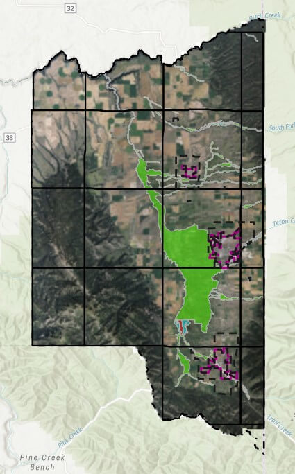
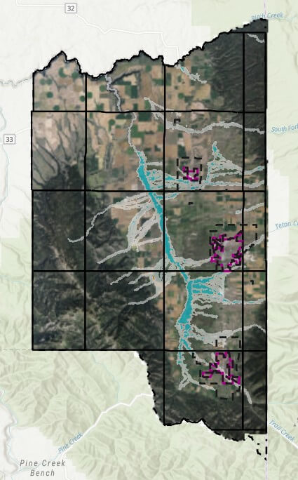
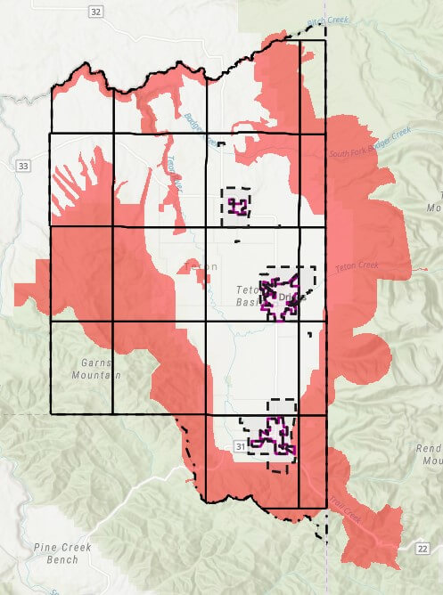
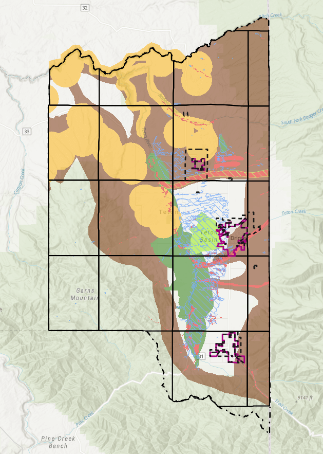
So, briefly, what is the Natural Resource Overlay? This is a mapped overlay adopted by Teton County to identify areas that are sensitive to wildlife and habitat. As I understand it, this data was gathered in conjunction with the Idaho Department of Fish and Game in 2022 as well as local experts and authorities. There are several overlays throughout the county identified below, I also created a map legend to help identify each.

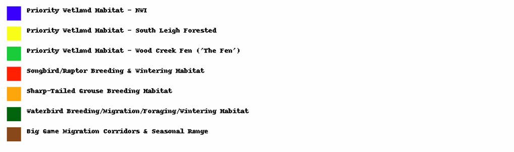
A quick note on Wetland areas:

I won’t go into too much detail relative to Wetland habitat areas including the main overlay, the South Leigh forested areas or the Wood Creek Fen areas. These areas not only trigger Wildlife considerations, but also Wetland specific review. My understanding is that the South Lee forested wetlands in the Woodcreek Bend are locally defined priority Wetlands not always visible in the federal data sets like the NWI, but they are treated similarly and may still require Wetland delineations or other studies. I have other articles where I dive into Wetland, so for now, we’ll focus on the remaining Wildlife overlays.

What is a WHA vs an A-AWA?

Wildlife Habitat Analysis (WHA)

I would consider a WHA as intended to be a more specific, detailed analysis of a given property for specific reasons, primarily Subdivision / Land division and Special Use Permit or Conditional Use Permit situations. These are extensive studies to look at the viability of a subdivision of land that meets all other requirements and eligibility for subdivision in the county. They might look at placement of building envelopes or parcel sizes as they pertain to proximity to sensitive areas or how they might impact sensitive areas. Similarly, special or conditional permits may require these more calculated, advanced studies. They typically include detailed field work, mapping, species analysis and an overall conservation plan. They must be prepared by a pre-qualified consultant according to the County’s data set (applicants that are not pre-qualified can apply) and are reviewed by planning staff before moving to concept plan stages. They take into account cumulative landscape impacts, Wildlife corridors, and conservation ratios.

Abbreviated Wildlife Habitat Analysis (A-WHA)

Abbreviated analyzes are required for building permits within the nro, are short form by comparison, and are approved by the Planning and Building Department before building permit approval. They focus on site level planning and proximity to known habitat or sensitive features and are intended to be streamlined for homeowners and small-scale projects, however, they are still currently required to be performed by Consultants that are approved by the county. Here again, applicants that are not pre-qualified, can apply.

What Triggers the Requirement for an Analysis?

Essentially, any parcel with identified indicator habitat species, mapped Wetland or riparian zones, and most easily identified, Parcels that are located inside one of the Natural Resource Overlays. HOWEVER, there are situations when properties can be exempt from these requirements:

The parcel containing the proposed project is exempt from the need for a
WHA or A-WHA if one or more of the following conditions applies:
– The parcel is located completely outside the boundaries of the NRO.
– The parcel is partially within the NRO but the proposed project site on
the parcel is at least 100 feet outside of the boundaries of the NRO
(this condition applies for building permit requests only).
– The parcel has previously undergone a county-approved natural
resource analysis (WHA or other).
– The parcel is under a conservation easement from an organization
accredited by the Land Trust Alliance and the building envelope has
already been identified in the recorded documents.
– The parcel is in a pre-existing platted neighborhood/subdivision and
is < 3 acre in size.
– The project is in an existing building envelope on the parcel.
– The project is for additional development fully contained within 50 feet
of existing development on the parcel.

In addition, The parcel is exempt from the need for a WHA or A-WHA if all three of the

following conditions apply:
– The parcel is in a pre-existing platted neighborhood/subdivision and
is > 3 acres and < 5 acres in size.
– The parcel is covered only by the “Big Game Migration Corridor &
Seasonal Range” layer of the NRO.
– The parcel has no USGS-designated perennial, seasonal or
intermittent stream courses present.

Breaking that down, the most likely scenario are properties that are in existing platted subdivisions and are less than 3 acres in size. Additionally, if the project is inside an existing building envelope, that could easily mitigate the requirement for one of these analyzes. Remodels should also be protected if the additional development is fully contained within 50 ft of existing development on the parcel. We do our best to provide resources that include approved contractors for these types of analysis on our brokerage website, make sure to make an account with one of our agents, and again, always confirm this information.

Teton County Idaho’s FEMA Flood Map Updates

September 22, 2024 By Tayson Rockefeller Leave a Comment

On September 18th, 2024, I attended an open house for a special board with Teton County in conjunction with a FEMA representative for the updated project timeline for new (long-awaited) floodplain maps. Obviously, the information below is my interpretation of that presentation, so always verify information with State, Local and Federal officials.

The purpose of the open house was to review the preliminary floodplain map data released on August 15th. This data was last updated in 1988 with the limited technology at the time. An attempt was made in 2011 to update the mapping with a LIDAR flyover of the county in 2011. However, Teton County GIS coordinator Rob Marin (thanks, Rob) pointed out some deficiencies based on the year and time of year that may have inadvertently resulted in inaccurate and exaggerated flood data. This led to another recent flyover with a greater level of accuracy based on the timing, and newer technology. This new data will lead the way for a 90-day appeal process for those that can provide strong evidence that the new map data is inaccurate. For any objections, it should be noted that a letter of final determination is expected in the Fall of 2025, with final maps taking effect early 2026. The 90 day appeal process is expected to begin in February of 2025 and end in May of 2025. Comments can be provided, and forms are available on site at the Teton County courthouse and online for these appeal processes. This could be something as simple as an incorrect street name, or a more significant appeal such as a formal objection with evidence of inaccuracies. An appeal requires quite a bit of work, and as such, will require some form of significant evidence as to the inaccuracy, usually involving engineering (data based) reports. However, these scenarios will be investigated. These should be provided to Teton County who will pass the comments along to FEMA.

With that out of the way, the meeting was informative as to the new data, how it is mapped, and how it can be beneficial to Teton County. In attendance at the meeting was a representative for FEMA’s Region 10, Marshall Rivers. FEMA’s primary concern is safety, predicting flood risk and preparing for flood events. The last time the flood maps were updated was 1988, and with vast, new technology, FEMA was able to map not only flood information, but ranges of flood risk (as well as a side benefit of 2 foot contour elevations now available from the county). This program for updating the data was in collaboration with local government and the National Flood Insurance Programs (NFIP) in conjunction with FEMA. The federal government is responsible for mapping communities on a continuing basis. The state governments prioritize areas for future mapping studies, and local governments provide local insight and support. They also integrate the data into planning mechanisms and processes.

How are the maps made?

The maps are made using ground survey and LIDAR technology to identify areas of floodplain. The floodplain is generally an area that can be affected by flood or high water. LIDAR is a laser-based aerial tool with extraordinary accuracy that can sense surprisingly small objects. As mentioned above, a byproduct includes two foot contour elevations across almost the entire county. This data can be used by surveyors or land owners for planning and building purposes. There are limitations to these maps which include some uncertainties or uncontrollable circumstances such as log jambs, changing rivers or even land impacted by wildfires. In addition to LIDAR, hydrology and measuring the flow of water is a big consideration in establishing these maps. FEMA worked with Teton County to add study zones with some tasks led by FEMA, and others led by Teton County and other agencies.

Updated Zones and Associated Risks

This new data offers a more granular prediction as to certain areas and their risk levels. Two types of flood hazards were mapped. The moderate flood risk (Yellow, when viewing the map) is intended to show a 0.2% annual chance of flooding (or less impactful areas), and high flood risk which is estimated to be a 1% annual chance of flooding (or more impactful areas). In addition, Floodway (as indicated in these maps in red), indicate areas that could be most impactful, and should be avoided. I was unable to determine the county’s future role in special requirements or restrictions in these areas.

Insurance 

Just because a home is not in one of these identified rest areas, does not mean that there is no risk of flood. Conversely, if your home is removed from these flood areas with the new mapping, it doesn’t necessarily mean that you should cancel your existing flood insurance. According to FEMA, one out of four people who have a claim are not in an area mapped and identified as a high-risk flood area. If your property is added into flood zones in these amended maps, you may be contacted by your lender (and should consider risk insurance, regardless). My understanding is that your flood risk is evaluated by your lender and insurance provider. If homes are built above the base flood elevation of the risk area, this can minimize the added cost, or potentially even the requirement for insurance. You can learn more (and confirm my beliefs) at floodsmart.gov. 

Base Flood Elevation & Development This new data will provide some instant data for what used to require elevation certificates to prove the base flood elevations. Information that may have once required an engineer to evaluate may now be immediately available with the new data. You do need a floodplain development permit whether you are handling infrastructure or building a home, but FEMA does not restrict development in floodplain areas.

OLD DATA (circa 1988)

NEW DATA (as of August 15th, 2024)

Teton County Land Development Code – Wildfire Hazard Areas

September 11, 2024 By Tayson Rockefeller Leave a Comment

As a continuation of the review of the Teton County Land Development Code, a short, but potentially impactful section of the code may affect a property of potential interest, or perhaps your own. This section is 5-4-3, Wildfire Hazard Overlays. Like many sections of the 2022 Land Development Code (LDC), the code does cross reference a “layer” or map overlay. Below is a high level overview of the areas affected by the Wildfire Hazard Areas. The areas affected by the Wildlife Hazard Areas are mostly limited to the perimeter foothills of the Teton Valley, but do include some areas of the valley floor.

As stated in the LDC, the intent of this area is “to protect the health and safety of structures in high-risk wildfire areas”. The greatest impacts of development is the requirement that principal structures shall be located within 200 feet of the primary public roadway to provide safe and efficient access for wildfire protection. In addition, a plan for management of vegetation and defensible space is required to be submitted with site plans, and fuel breaks are to be implemented along access roads, driveways and subdivision boundaries, as well as defensible space provided around principal structures for the International Wildlife-Urban Interface Code (WUI Code). The website for the WUI code can be found here. As a side note, it is expected that ALL of Teton County may be required to conform to the WUI Code.

As with many aspects of our relatively “young” LDC (first established August 2022) these limitations can create challenges for certain properties. At the time of this writing, a few concerns might include (but may not be limited to);

  • Properties where the designated building envelope is further than 200 feet from the public roadway
  • Properties where the most suitable building site (for reasons other than fire hazard) is further than the public roadway
  • Large acreages within 200 feet of a public roadway
  • New subdivision along public roadways

As a final note, the LDC does specifically state “public roadway” when referencing the 200′ distance requirement. As a result, I do expect further discussion at the county level to better define roadways and mitigation requirements for properties that are further than 200′ from public roadways in and of themselves.

Similar to other overlays and code requirements, it is recommended that potential Buyers and Land Owners review ALL aspects of the local codes and ordinances. In the instance of the Wildfire Hazard Overlays, it is recommended that contact is made to a Teton County, Idaho Planning or Building representative to understand current requirements, interpretations and future amendments.

*Wildfire Hazard Overlays as of September 11th, 2024.

Reviewing the Code – A Summary of Considerations when Buying Land in Teton County

August 13, 2024 By Tayson Rockefeller Leave a Comment

As a quick note prior to diving in, this article applies to the unincorporated areas of Teton County. The City limits of Driggs, Victor and Tetonia have their own Land Use/Development Code. Much of this was covered in Part III of my review of Teton County’s newest (2022) Land Development Code article, but I wanted to take some time to quickly highlight some of the things to watch out for when looking at undeveloped land as an investment and for future development – keeping in mind that these code requirements are obviously subject to change. We seem to be through a good portion of code revisions, and there also seems to be some more solid direction from Teton County with respect to these processes.

Zoning
There are several zoning types in Teton County, Idaho, and it is important to understand that each have their own special requirements for development or splitting property, and each have specific uses. While residential use (building a home) is generally permitted on all parcels and zoning types, it is also important to know that properties that were split illegally such as deed splits without a subdivision process after June 14th, 1999 may not have building rights. Similarly, properties that were split by way of an agricultural split may not have property rights. Much of this information can be verified with Teton County via a “Zoning Verification Request” which does come with a cost (currently $150) but this would generally be less of a concern with any property that is in a platted development. You can read my article on the different zoning types, here.

Flood Hazard
This one is still a bit tricky as FEMA has not completed the draft floodplain Maps. In either case, if a property, be it under the existing floodplain map or the future implemented map, Falls within these areas, the county will require elevation certificates before, during and after the build to make sure that the floor system of the home is above the base flood elevation requirements. Additionally, it should be considered whether flood insurance will be required, regardless of the project elevation upon completion even if the county is satisfied.

Wetland
I just wrote an article on wetland, it can be found, here. For parcels that require a wetland delineation (despite my disagreement with this) the county would prefer that the entire parcel be delineated to provide a holistic overview of the parcel, and to better tie in with Wildlife Analyses, if required.

Natural Resource Overlay (NRO)
Teton County is working on a new draft overlay of Teton County’s natural resources which expands most of the historic wildlife overlays. This one was enough for me to wrap my head around, but basically, if a parcel has an overlay where the site is intended to be improved, a shorthand wildlife analysis is required. This includes maps that show the existing boundaries of the applicable overlay, and some reasonable expertise for a development plan. At the time of this writing, I was told by Teton County that no specific qualifications were needed for this shorthand version of a wildlife analysis, otherwise known as an Abbreviated Wildlife Habitat Analysis (A-WHA). For more in-depth projects such as Land Development, subdividing and so forth, far more extensive analyses may be required which would constitute a full Wildlife Habitat Analysis (WHA). I am linking the policy here, but keep in mind that this is subject to change. Properties that have designated building in the lowest may not require Wildlife Habitat Analyses, even if the NRO layer encompasses all or a portion of the predetermined building envelope.

Hillside Overlay
Certain areas of the Teton Valley are encompassed by a “Hillside Overlay”. Obviously, most of these areas are going to be in areas with steeper terrain, and may have special requirements. In extreme cases, development may not be possible under the current code. This should be considered for accessing parcels in these areas as well as site planning for construction.

Scenic Corridor Overlay
The scenic Corridor overlay encompasses approximately 500 ft from State Highway 31, 32 and 33 as well as Ski Hill Road. Areas that fall within this overlay may have specific height limitations. However, the county code has an amendment in the works to allow variances without a public hearing (which is currently required) if a visual site analysis (what the project may look like from the road) is provided and it is concluded that it is not obtrusive. They are also some additional requirements with respect to design, which could include architectural styles, colors, and so forth. Special landscaping requirements may be implemented as well, which could include berms, trees, screening, etc.

There are several other overlays that, while they may not have any specific impact on one’s ability to improve a parcel, may be considered. Examples include the bear conflict Zone which requires bear proof trash cans, wildlife hazards, and even an understanding of roads that may not be maintained in the winter months, or maintained by the county at all. Other layers and restrictions still exist which obviously include subdivision restrictions, County setbacks and other code requirements including driveway lengths and a variety of other Land Development Code policies.

  • 1
  • 2
  • 3
  • Next Page »

Recent Testimonials

  • Douglas V.
  • Chuck M.
  • Terry & Joy K.
Teton Valley Realty
Copyright Teton Realty Blog© 2025 - Tayson Rockefeller - [email protected] - 208-709-1333 - sitemap | Privacy Policy, Copyright & Terms of Use