Teton Realty Blog

Teton Region Real Estate Market Stats, Articles & News

  • Home
  • Listings ‘N Stuff
    • Property Search
    • Search Account
  • The Blog
    • Buyers
    • Sellers
    • Local Info
    • Market Reports
    • Know Your Home
    • 2022 Teton County, ID Code
    • Pages & Categories
  • About/Contact Me
    • Contact Me
    • About Me
    • Testimonials
  • Log In/Subscribe
    • Account Set-Up/Log-In
    • Weekly Newsletter
  • Facebook
  • LinkedIn
  • YouTube

HOAs vs Pragmatism

April 3, 2025 By Tayson Rockefeller Leave a Comment

An interesting dynamic that has emerged over the years is the unanticipated change in lifestyle, business practices, zoning updates, county regulations, and state regulations affecting simple, common-sense aspects of everyday living.

One of the most common examples I have referenced over the years is short-term rental regulations. Idaho legislation is widely known for protecting property rights, including the right to rent a home—more specifically, for short-term or vacation rentals. There is, however, a provision allowing homeowners associations (HOAs) to prohibit short-term rentals (typically defined as stays of 30 nights or fewer). The issue is that most of Teton Valley’s new subdivisions were established around 2007, during the last real estate boom. While there was a vacation rental industry at that time, it was still in its early stages. I recall that our in-house property management firm, Teton Valley Property Management, initially used reservation software similar to what a hotel might use. The industry didn’t truly take off until the last real estate boom, coinciding with Airbnb’s launch in 2008.

Many new subdivisions during that period copied previous development covenants and restrictions, making only slight modifications to fit the new developments. As a result, they often failed to account for the potential rise of short-term rentals, even if the original intent was to prevent them. Consequently, nearly every subdivision in Teton Valley allows short-term rentals. Since the last real estate boom, new communities have been established, though they have become less frequent due to zoning density changes and new subdivision requirements. Even so, new developers typically avoid prohibiting rentals out of fear of alienating potential buyers who may see rental income as an advantage.

While the longstanding controversy over short-term rentals is an easy topic to discuss, there are other noteworthy examples of the tension between HOA restrictions and evolving realities.

Environmental Changes

I think we can all generally agree that climate change is real at this point. While this isn’t a topic I typically cover in my neutral real estate blog, it does relate to issues like wildfire resistance. Some communities still require natural wood siding and even shake shingle roofs. As of this writing, Teton Valley has been fortunate to avoid dramatic increases in insurance rates and has experienced very few natural disasters. However, a brush fire in 2024 was one of the first significant fires within the valley in my memory. Despite this, some subdivisions continue to resist changes that would allow for more fire-resistant building materials.

Build-Out and Subdivision Maturity

Issues tend to arise as subdivisions develop. It’s surprising how many communities in Teton Valley remain mostly or partially undeveloped, often due to land investors holding onto property, even if it is just to own a “piece” of Teton Valley. However, some communities are beginning to build out rapidly. While 2007 was a land development boom, the recent uptick in Teton Valley has primarily been in residential development.

Fortunately, most property owners have been considerate of their neighbors when developing. For example, in Teton View corridor neighborhoods without designated building envelopes, many owners stagger their homes to preserve both their own views of the Tetons and those of their neighbors. Even when unintentional, local knowledge of the landscape and architectural intuition tend to guide development in a way that takes advantage of the surrounding beauty. However, this isn’t always the case. Not all property owners are neighborly, and some development factors were not thoroughly vetted during the planning process. I’ve seen multiple subdivisions require amendments to plat maps or building envelopes to accommodate practical adjustments. While HOAs are often cooperative in such cases—particularly when county variances require it—the process of amending subdivision documents can be cumbersome, especially when no formal association has been established.

Zoning Changes

This is the big one. In August 2022, the county introduced an entirely new land development code and zoning map. This update cut densities nearly in half, revised overlays, and altered development processes. While existing parcels were grandfathered in terms of density (for example, a properly subdivided 2.5-acre parcel now within a 5-acre density zone remains buildable), other changes present challenges. Here are a few key examples:

Scenic Corridor Overlay

The new scenic corridor overlay affects properties within 500 feet of Ski Hill Road. Under the new regulations, landowners may need to modify development plans to comply with overlay requirements. The county does not enforce subdivision covenants, conditions & restrictions, but its development guidelines supersede those of subdivisions. This can create conflicts when subdivision guidelines contradict county zoning restrictions. Fortunately, the county often grants variances to accommodate developers and subdivisions, though it adds an extra layer of complexity.

Wildlife Overlay

Zoning changes have also impacted properties within designated wildlife and natural resource overlays. While most subdivision parcels under five acres are now exempt from additional requirements, some still face complications. For example, an overlay may sit directly on a planned building site, requiring a variance or adjustment that could conflict with existing subdivision plats.

Wetland and Floodplain Overlays

These overlays have been revised, and riparian buffer setbacks have increased. Even if a wetland delineation was approved years ago, the Army Corps of Engineers has expiration timelines for delineation approvals. As a result, landowners may find that new setbacks prohibit development in previously intended areas. Again, variances are possible, but they add another hurdle for landowners and developers.

Setback Requirements

Simple setback changes can also cause issues. Some subdivisions were designed with minimal setbacks based on previous zoning regulations. If the required setbacks have increased, buildable areas may be reduced, making development more difficult.

Why Not Simply Modify HOA Covenants?

Given these challenges, one might ask: why not update subdivision covenants and HOA policies? While this seems like a logical solution, it is often easier said than done. Many subdivision bylaws require a majority—or even a supermajority—of homeowners to approve amendments. This typically necessitates board meetings, formal votes, and recorded signatures. In my experience, this is a difficult process. Many investors and homeowners are resistant to change, especially if it could affect property values, rental income, or architectural consistency within a community.

Final Thoughts

Despite these challenges, it’s important to note that very few lots are significantly impacted by zoning or covenant conflicts. Still, prospective buyers and developers should carefully review subdivision documents and reach out to HOA representatives when possible. While these changes introduce new complexities, I believe that practical solutions will emerge over time. County officials have reassured me that properly subdivided parcels remain buildable, even if new regulations introduce obstacles. Additional challenges—such as septic system requirements in wet areas and rising construction costs—may also arise.

Teton Valley is still in the early stages of its growth, despite the substantial expansion we’ve seen. I anticipate further zoning updates, new comprehensive plans, and evolving industry standards will continue to shape the landscape (no pun intended). But if history is any indication, just like past controversial real estate issues in Teton Valley, my prediction remains simple: things will work themselves out.

Election Volatility (2024 Edition)

November 19, 2024 By Tayson Rockefeller Leave a Comment

Back in 2016, I wrote an article about what the election might mean for your real estate. After reviewing some interesting articles and data points, my conclusion was that real estate is much more impacted by market cycles than it is by election cycles. That being said, I did note some short-term volatility leading up to, and shortly after that election. This was true at that time, and here we are once again. In fact, the article was published at about this same time in 2016.

Having been through multiple election cycles over my years in real estate, I know this to be the case, but I was reminded of my 2016 article and talking points after receiving a market trends article written by Jordan Teicher for Zillow. As Brokers, we receive “market insider” information from the real estate giant. Despite my mixed feelings about Zillow, I still participate in advertising and follow their data points, trends and articles.

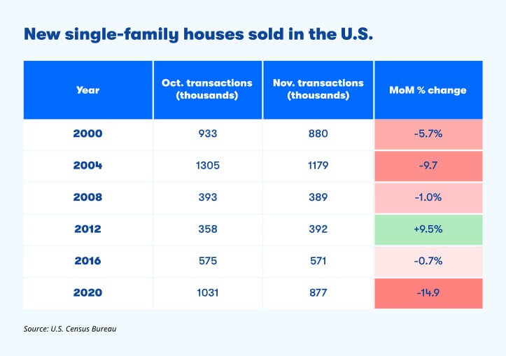
Jordan’s article dissected many common claims about reports of market volatility during election seasons and the claim that people are reluctant to move during these times. He was able to crunch some of the numbers using data from the US Census Bureau which confirmed a typical November slowdown following five of the last six presidential election years. The average month over month change during those six election cycles was -3.7% with only 2012 capturing a positive net change in the November following that election.

He went on to note that comparatively, in years without presidential elections, home sales increased an average of 0.6% between October and November. Over the past 20 years, he notes that transactions actually increased by an average of more than double all other years in December following presidential elections, “suggesting there may have been pent-up demand returning from those who were waiting to see how the election would play out.”

While none of this data may be surprising (it certainly is not to me) it does confirm what we think will continue to happen, a stabilizing market and likely an increase in sales as we move into the Winter peak season here in Teton Valley. As mentioned back in 2016, I believe the market will continue to be shaped by market supply and demand (and interest rates). 2020 threw us for a loop with diminishing supply and overwhelming demand, now with National trends pointing towards continued lack of supply with respect to housing starts. This broad dilemma and the theories behind it are further reinforced by micro factors in our own market including building costs and development challenges associated with growing pains and the continued challenges associated with a new Zoning and Land Development Code throughout Teton County.

Interested in a few associated articles? Don’t forget to check out the following links:

Driving Factors behind Interest Rates (2022)

Teton County Land Development Code

Sources:
– https://www.zillow.com/agent-resources/blog/presidential-election-housing-market/
– U.S. Census Bureau

Teton County Idaho’s FEMA Flood Map Updates

September 22, 2024 By Tayson Rockefeller Leave a Comment

On September 18th, 2024, I attended an open house for a special board with Teton County in conjunction with a FEMA representative for the updated project timeline for new (long-awaited) floodplain maps. Obviously, the information below is my interpretation of that presentation, so always verify information with State, Local and Federal officials.

The purpose of the open house was to review the preliminary floodplain map data released on August 15th. This data was last updated in 1988 with the limited technology at the time. An attempt was made in 2011 to update the mapping with a LIDAR flyover of the county in 2011. However, Teton County GIS coordinator Rob Marin (thanks, Rob) pointed out some deficiencies based on the year and time of year that may have inadvertently resulted in inaccurate and exaggerated flood data. This led to another recent flyover with a greater level of accuracy based on the timing, and newer technology. This new data will lead the way for a 90-day appeal process for those that can provide strong evidence that the new map data is inaccurate. For any objections, it should be noted that a letter of final determination is expected in the Fall of 2025, with final maps taking effect early 2026. The 90 day appeal process is expected to begin in February of 2025 and end in May of 2025. Comments can be provided, and forms are available on site at the Teton County courthouse and online for these appeal processes. This could be something as simple as an incorrect street name, or a more significant appeal such as a formal objection with evidence of inaccuracies. An appeal requires quite a bit of work, and as such, will require some form of significant evidence as to the inaccuracy, usually involving engineering (data based) reports. However, these scenarios will be investigated. These should be provided to Teton County who will pass the comments along to FEMA.

With that out of the way, the meeting was informative as to the new data, how it is mapped, and how it can be beneficial to Teton County. In attendance at the meeting was a representative for FEMA’s Region 10, Marshall Rivers. FEMA’s primary concern is safety, predicting flood risk and preparing for flood events. The last time the flood maps were updated was 1988, and with vast, new technology, FEMA was able to map not only flood information, but ranges of flood risk (as well as a side benefit of 2 foot contour elevations now available from the county). This program for updating the data was in collaboration with local government and the National Flood Insurance Programs (NFIP) in conjunction with FEMA. The federal government is responsible for mapping communities on a continuing basis. The state governments prioritize areas for future mapping studies, and local governments provide local insight and support. They also integrate the data into planning mechanisms and processes.

How are the maps made?

The maps are made using ground survey and LIDAR technology to identify areas of floodplain. The floodplain is generally an area that can be affected by flood or high water. LIDAR is a laser-based aerial tool with extraordinary accuracy that can sense surprisingly small objects. As mentioned above, a byproduct includes two foot contour elevations across almost the entire county. This data can be used by surveyors or land owners for planning and building purposes. There are limitations to these maps which include some uncertainties or uncontrollable circumstances such as log jambs, changing rivers or even land impacted by wildfires. In addition to LIDAR, hydrology and measuring the flow of water is a big consideration in establishing these maps. FEMA worked with Teton County to add study zones with some tasks led by FEMA, and others led by Teton County and other agencies.

Updated Zones and Associated Risks

This new data offers a more granular prediction as to certain areas and their risk levels. Two types of flood hazards were mapped. The moderate flood risk (Yellow, when viewing the map) is intended to show a 0.2% annual chance of flooding (or less impactful areas), and high flood risk which is estimated to be a 1% annual chance of flooding (or more impactful areas). In addition, Floodway (as indicated in these maps in red), indicate areas that could be most impactful, and should be avoided. I was unable to determine the county’s future role in special requirements or restrictions in these areas.

Insurance 

Just because a home is not in one of these identified rest areas, does not mean that there is no risk of flood. Conversely, if your home is removed from these flood areas with the new mapping, it doesn’t necessarily mean that you should cancel your existing flood insurance. According to FEMA, one out of four people who have a claim are not in an area mapped and identified as a high-risk flood area. If your property is added into flood zones in these amended maps, you may be contacted by your lender (and should consider risk insurance, regardless). My understanding is that your flood risk is evaluated by your lender and insurance provider. If homes are built above the base flood elevation of the risk area, this can minimize the added cost, or potentially even the requirement for insurance. You can learn more (and confirm my beliefs) at floodsmart.gov. 

Base Flood Elevation & Development This new data will provide some instant data for what used to require elevation certificates to prove the base flood elevations. Information that may have once required an engineer to evaluate may now be immediately available with the new data. You do need a floodplain development permit whether you are handling infrastructure or building a home, but FEMA does not restrict development in floodplain areas.

OLD DATA (circa 1988)

NEW DATA (as of August 15th, 2024)

Teton County Land Development Code – Wildfire Hazard Areas

September 11, 2024 By Tayson Rockefeller Leave a Comment

As a continuation of the review of the Teton County Land Development Code, a short, but potentially impactful section of the code may affect a property of potential interest, or perhaps your own. This section is 5-4-3, Wildfire Hazard Overlays. Like many sections of the 2022 Land Development Code (LDC), the code does cross reference a “layer” or map overlay. Below is a high level overview of the areas affected by the Wildfire Hazard Areas. The areas affected by the Wildlife Hazard Areas are mostly limited to the perimeter foothills of the Teton Valley, but do include some areas of the valley floor.

As stated in the LDC, the intent of this area is “to protect the health and safety of structures in high-risk wildfire areas”. The greatest impacts of development is the requirement that principal structures shall be located within 200 feet of the primary public roadway to provide safe and efficient access for wildfire protection. In addition, a plan for management of vegetation and defensible space is required to be submitted with site plans, and fuel breaks are to be implemented along access roads, driveways and subdivision boundaries, as well as defensible space provided around principal structures for the International Wildlife-Urban Interface Code (WUI Code). The website for the WUI code can be found here. As a side note, it is expected that ALL of Teton County may be required to conform to the WUI Code.

As with many aspects of our relatively “young” LDC (first established August 2022) these limitations can create challenges for certain properties. At the time of this writing, a few concerns might include (but may not be limited to);

  • Properties where the designated building envelope is further than 200 feet from the public roadway
  • Properties where the most suitable building site (for reasons other than fire hazard) is further than the public roadway
  • Large acreages within 200 feet of a public roadway
  • New subdivision along public roadways

As a final note, the LDC does specifically state “public roadway” when referencing the 200′ distance requirement. As a result, I do expect further discussion at the county level to better define roadways and mitigation requirements for properties that are further than 200′ from public roadways in and of themselves.

Similar to other overlays and code requirements, it is recommended that potential Buyers and Land Owners review ALL aspects of the local codes and ordinances. In the instance of the Wildfire Hazard Overlays, it is recommended that contact is made to a Teton County, Idaho Planning or Building representative to understand current requirements, interpretations and future amendments.

*Wildfire Hazard Overlays as of September 11th, 2024.

  • « Previous Page
  • 1
  • 2
  • 3
  • 4
  • …
  • 25
  • Next Page »

Recent Testimonials

  • Douglas V.
  • Chuck M.
  • Terry & Joy K.
Teton Valley Realty
Copyright Teton Realty Blog© 2025 - Tayson Rockefeller - [email protected] - 208-709-1333 - sitemap | Privacy Policy, Copyright & Terms of Use